1980s Maps of Forrest, Illinois
Explore 3 historic maps of Forrest from the 1980s. These maps offer a rare glimpse into what life looked like during the 1980s — showing old roads, neighborhoods, homes, and landmarks that have changed or disappeared over time.
Whether you're researching your family's past, planning a metal detecting trip, or studying how Forrest's landscape evolved across the 1980s, these high-resolution maps are a powerful tool for exploring the history of this region.
- Focus on a specific era: All maps on this page are from the 1980s, giving you a focused view of this time period.
- See what’s changed: Compare century-old streets, trails, and buildings to today's modern landscape using overlays and satellite layers.
- Research with precision: Use these maps for genealogy, historical research, land use analysis, or educational projects.
- View, download, or print: Maps are fully viewable online in high resolution, and can be downloaded or printed for your own records.
Start exploring Forrest's history through authentic maps from the 1980s. This is your window into the past.
Forrest, IL maps
(3)- 1983 Map of Forrest North
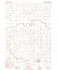 1983 Forrest North1983 Print · USGSLivingston County as it appeared in the early 1980s shows a landscape of productive prairie farmland and critical rail junctions. Genealogists and local historians can locate rural landmarks like St Johns Cem, Emanuel Ch, and the small settlement of Wing.
 - 1985 Map of Fairbury
 1985 Fairbury1985 Print · USGSCentral Illinois in the mid-1980s reveals a landscape shaped by the Illinois Central Gulf rail network and the Vermilion River basin. Trace the roots of local communities from Fairbury to Pontiac, and locate landmarks like the State Correctional Center and High Chapel.2 unique versions available
 - 1986 Map of Forrest South
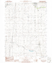 1986 Forrest South1986 Print · USGSLivingston County's agricultural heartland is captured here in the mid-1980s, showing the rural grid and prairie waterways. Trace the old village footprints of Strawn, Risk, and Forrest alongside the winding course of the South Fork Vermilion River.
End of results
Showing maps 1-3 of 3
Top cities near Forrest
- Pontiac historical maps
- Fairbury historical maps
- Chatsworth historical maps
- Colfax historical maps
- Piper City historical maps
- Cullom historical maps
See more
Frequently asked questions
- What are the different types of historical maps available for Forrest?
- What is the oldest map of Forrest?
- Where can I purchase historical maps of Forrest for my home or office?
- Where can I download high-res historical maps of Forrest?
- Are there historical topographic maps available for Forrest?
- Is there historical aerial imagery available for Forrest?
- Where are historical maps of Forrest sourced from?