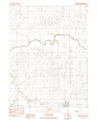
1983 Map of Forrest North
USGS Topo · Published 1983About this map
Forrest occupies the southeastern corner of this Illinois prairie landscape, positioned where the Norfolk and Western rail lines converge. The surrounding townships of Pleasant Ridge, Owego, and Saunemin are defined by a grid of rural roads and scattered farmsteads, punctuated by local spiritual and memorial sites such as Emanuel Ch and the North Apostolic Christian Cem. This 1980s data shows a land deeply connected to agriculture and small-scale aviation, evidenced by private airstrips like the Langstaff Landing Field and Immke Landing Strip.
Find a feature on this map
26 named features on this map. Tap any name to fly to it.
Don’t see what you’re looking for? This feature index may not catch every label — zoom into the map to look around manually.
Map Details
Editions of this 1983 Forrest North Map
This is the sole edition of this map. No revisions or reprints were ever made.
Other maps of this area

1935 · Pontiac
USGS Topo · 1:62,500

1939 · Pontiac
USGS Topo · 1:62,500

1947 · Sibley
USGS Topo · 1:62,500

1947 · Cullom
USGS Topo · 1:62,500

1949 · Cullom
USGS Topo · 1:62,500

1949 · Sibley
USGS Topo · 1:62,500

1957 · Colfax
USGS Topo · 1:62,500

1958 · Peoria
USGS Topo · 1:250,000

1961 · Peoria
USGS Topo · 1:250,000

1963 · Peoria
USGS Topo · 1:250,000