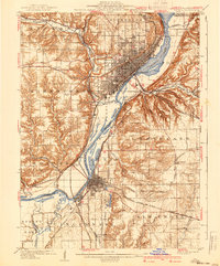
1961 Map of Peoria
USGS Topo · Published 1961About this map
The Illinois River valley serves as the industrial and geographical heart of this mid-century survey, with Peoria and Pekin dominating the riverfront. To the south, the sprawling grounds of Chanute AFB near Rantoul and the University of Illinois in Urbana and Champaign mark significant institutional anchors. The landscape is a lattice of rail lines, including the Illinois Central, Wabash, and the Illinois Terminal, which linked the agricultural and manufacturing centers of Bloomington, Normal, and Clinton.
Find a feature on this map
105 named features on this map. Tap any name to fly to it.
Don’t see what you’re looking for? This feature index may not catch every label — zoom into the map to look around manually.
Map Details
Editions of this 1961 Peoria Map
This is the sole edition of this map. No revisions or reprints were ever made.
Historical Maps of Peoria Through Time
8 maps found