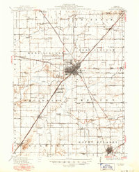
1911 Map of Lincoln
USGS Topo · Published 1967About this map
Lincoln serves as the central hub of this Central Illinois landscape, where a dense network of steam and electric railways converge. The city is a crossroads for the Illinois Central, Chicago and Alton, and the Illinois Traction System, reflecting a peak era of rail transport before the dominance of the automobile. Beyond the urban center, the countryside is organized into a rigid grid of townships like Eminence and Mount Pulaski, each dotted with namesake country schools such as Lone Tree School and Honeyhook School. The drainage of Salt Creek and its tributaries like Kickapoo Creek dictates the placement of early settlements and river crossings. Unique local landmarks including the County Farm, the State Reservation, and the Airfield near the city center highlight the transition between agrarian life and early 20th-century institutional and technological growth.
Find a feature on this map
72 named features on this map. Tap any name to fly to it.
Don’t see what you’re looking for? This feature index may not catch every label — zoom into the map to look around manually.
Map Details
Editions of this 1911 Lincoln Map
This is the sole edition of this map. No revisions or reprints were ever made.
Historical Maps of Lincoln Through Time
4 maps found