
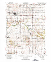
1948 Map of Mason City
USGS Topo · Published 1963About this map
Mason City and the surrounding prairie of Central Illinois are defined by a complex intersection of mid-century rail lines, including the Pennsylvania, Chicago And Alton, and Gulf Mobile And Ohio railroads. This network supported a landscape of small agricultural settlements and rural schoolhouses such as Honey Heart Sch and Spring Bank Sch. The terrain is shaped by the meandering courses of Salt Creek and Sugar Creek, where the boundaries of Mason, Logan, and Menard counties meet.
Find a feature on this map
59 named features on this map. Tap any name to fly to it.
Don’t see what you’re looking for? This feature index may not catch every label — zoom into the map to look around manually.
Map Details
Editions of this 1948 Mason City Map
2 editions found
Other maps of this area

1907 · Springfield
USGS Topo · 1:62,500

1909 · Tallula
USGS Topo · 1:62,500

1911 · Lincoln
USGS Topo · 1:62,500

1913 · Lincoln
USGS Topo · 1:62,500

1929 · Manito
USGS Topo · 1:62,500

1930 · Springfield
USGS Topo · 1:62,500

1932 · Manito
USGS Topo · 1:62,500

1933 · Petersburg
USGS Topo · 1:62,500

1938 · Petersburg
USGS Topo · 1:62,500

1940 · Tallula
USGS Topo · 1:62,500