
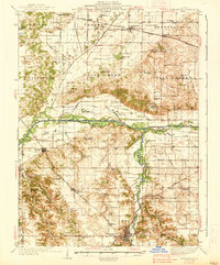
1938 Map of Petersburg
USGS Topo · Published 1938About this map
Petersburg serves as the focal point of this 1930s landscape, where the Sangamon River carves a winding path through Central Illinois. The map reveals an agrarian economy heavily reliant on rail transport, with the Illinois Central and Alton railroads connecting rural settlements like Oakford, Easton, and Atterbury P O. This era shows a high density of country schools and named groves, such as Sears Grove Sch and Haw Grove Sch, suggesting a community structure built around small local precincts. Industrial activity is concentrated along the river and rail corridors, evidenced by the Riverside Mine and a Hemp Factory near the Menard county seat. Notable for genealogists are the numerous family-named landmarks and burial grounds, including the Watkins Cem and Concord Cem, which provide a clear record of local settlement patterns before the mid-century consolidation of rural districts.
Find a feature on this map
121 named features on this map. Tap any name to fly to it.
Don’t see what you’re looking for? This feature index may not catch every label — zoom into the map to look around manually.
Map Details
Editions of this 1938 Petersburg Map
2 editions found
Other maps of this area

1907 · Springfield
USGS Topo · 1:62,500

1909 · Tallula
USGS Topo · 1:62,500

1925 · Havana
USGS Topo · 1:62,500

1929 · Manito
USGS Topo · 1:62,500

1930 · Chandlerville
USGS Topo · 1:62,500

1930 · Springfield
USGS Topo · 1:62,500

1932 · Chandlerville
USGS Topo · 1:62,500

1932 · Manito
USGS Topo · 1:62,500

1932 · Virginia
USGS Topo · 1:62,500

1933 · Petersburg
USGS Topo · 1:62,500