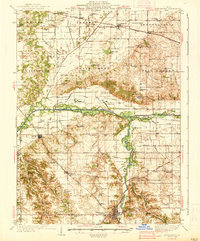
1938 Map of Petersburg
USGS Topo · Published 1938About this map
Petersburg serves as the focal point for this late-1930s survey, situated along the winding curves of the Sangamon River. The landscape reveals a dense network of rural infrastructure, from the Fairground on the edge of town to the Riverside Mine and Verbrugge Mine that anchor the local industrial economy. The drainage patterns of the Central Ditch and numerous sloughs like Perry Slough suggest a region heavily managed for agriculture, supported by a grid of schoolhouses such as Little Grove Sch and Walker Grove Sch.
Find a feature on this map
91 named features on this map. Tap any name to fly to it.
Don’t see what you’re looking for? This feature index may not catch every label — zoom into the map to look around manually.
Map Details
Editions of this 1938 Petersburg Map
2 editions found

Other maps of this area

1907 · Springfield
USGS Topo · 1:62,500

1909 · Tallula
USGS Topo · 1:62,500

1925 · Havana
USGS Topo · 1:62,500

1929 · Manito
USGS Topo · 1:62,500

1930 · Chandlerville
USGS Topo · 1:62,500

1930 · Springfield
USGS Topo · 1:62,500

1932 · Chandlerville
USGS Topo · 1:62,500

1932 · Manito
USGS Topo · 1:62,500

1932 · Virginia
USGS Topo · 1:62,500

1933 · Petersburg
USGS Topo · 1:62,500