1963 Map of Peoria
USGS Topo · Published 1963About this map
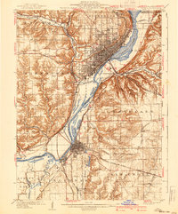
Peoria and its industrial neighbor Pekin serve as the primary hubs along the Illinois River in this detailed survey of Central Illinois. The landscape is defined by the convergence of major transportation corridors, where railroads like the Illinois Central Railroad and Gulf Mobile and Ohio Railroad intersect with the expanding postwar highway system, including Interstate 74 and Interstate 55. This era shows the region at a peak of agricultural and logistical importance, with the Grand Prairie punctuated by vital centers such as Bloomington, Normal, and the university cities of Champaign and Urbana. To the east, Chanute Air Force Base near Rantoul marks a significant military presence. Waterways like the Sangamon River and Mackinaw River provide the natural drainage for these fertile plains, while Sand Ridge State Forest and Jubilee College State Park represent preserved pockets of the original Illinois timber and sand prairie environments.
Find a feature on this map
187 named features on this map. Tap any name to fly to it.
Don’t see what you’re looking for? This feature index may not catch every label — zoom into the map to look around manually.
Map Details
Editions of this 1963 Peoria Map
This is the sole edition of this map. No revisions or reprints were ever made.
Historical Maps of Peoria Through Time
8 maps found