1900s (20th Century) Maps of Centralia, Illinois
Explore 12 historic maps of Centralia from the 1900s (20th Century). These maps offer a rare glimpse into what life looked like during the 1900s — showing old roads, neighborhoods, homes, and landmarks that have changed or disappeared over time.
Whether you're researching your family's past, planning a metal detecting trip, or studying how Centralia's landscape evolved across the 1900s, these high-resolution maps are a powerful tool for exploring the history of this region.
- Focus on a specific era: All maps on this page are from the 1900s, giving you a focused view of this time period.
- See what’s changed: Compare century-old streets, trails, and buildings to today's modern landscape using overlays and satellite layers.
- Research with precision: Use these maps for genealogy, historical research, land use analysis, or educational projects.
- View, download, or print: Maps are fully viewable online in high resolution, and can be downloaded or printed for your own records.
Start exploring Centralia's history through authentic maps from the 1900s. This is your window into the past.
Centralia, IL maps
(12)- 1914 Map of Centralia
 1914 Centralia1914 Print · USGSSouthern Illinois at the peak of the rail era shows a landscape of busy junctions and tightly-knit rural school districts. Genealogists and historians can trace family locations near landmarks like Possumtrot School, Fikes Hill, and the bustling yards of Centralia.3 unique versions available
 - 1935 Map of Centralia, 1958 Print
 1935 Centralia1958 Print · USGSCentralia and the surrounding Marion County townships thrived as a major railroad crossroads in the mid-1930s. Researchers can locate dozens of localized rural schoolhouses like Red Stripe and Possumtrot School or trace the early paths of the Illinois Central through Sandoval and Odin.
 - 1943 Map of Ashley, 1967 Print
 1943 Ashley1967 Print · USGSSouthern Illinois during the early 1940s is captured here as a thriving rail and agricultural hub. Genealogists can locate specific family-linked landmarks like the Blissville Polling House, Conta Colliery, and the Odd Fellows Cem.
 - 1946 Map of Ashley
 1946 Ashley1946 Print · USGSSouthern Illinois at the end of the war was a landscape of concentrated rail corridors and rural school districts. Genealogists can trace family roots through dozens of local landmarks like St Michael Cem, Oniontown, and the Blissville Polling House.
 - 1958 Map of Belleville, 1973 Print
 1958 Belleville1973 Print · USGSSouthern Illinois during the mid-twentieth century reveals a landscape of industrial growth and massive new reservoirs. Genealogists and historians can trace the paths of the Illinois Central RR through towns like Centralia or locate landmarks such as Emerald Mound and the Looking Glass Prairie.3 unique versions available
 - 1962 Map of Belleville
 1962 Belleville1962 Print · USGSSouthern Illinois in the late fifties reveals a landscape of industrial growth and ancient landmarks before the full expansion of the interstate system. Genealogists can trace family names and rural post offices near Centralia, Salem, and the historic Monks Mound.
 - 1969 Map of Centralia West, 1971 Print
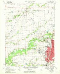 1969 Centralia West1971 Print · USGSCentralia and Wamac are shown at a peak of industrial and institutional growth in the late sixties. Researchers can trace family roots through numerous sites like Bethlehem Cem, Kaskaskia College, and the busy Junction City (Glen Ridge Station).2 unique versions available
 - 1970 Map of Centralia East, 1971 Print
 1970 Centralia East1971 Print · USGSMarion County at the start of the 1970s reveals a landscape of industrial energy and deep-rooted rural communities. Trace the intersection of the Illinois Central railroad with local landmarks like the Raccoon Lake Oil Field and Peaceful Valley Cem.3 unique versions available
 - 1974 Map of Walnut Hill, 1978 Print
 1974 Walnut Hill1978 Print · USGSMarion and Jefferson counties are shown here in the mid-seventies, captured at the intersection of the regional railroad network and the local oil industry. Researchers can trace family sites at Gaston Cem, Grand Prairie Sch, and the small settlement of Cravat.
 - 1974 Map of Irvington, 1978 Print
 1974 Irvington1978 Print · USGSSouthern Illinois oil production and rail transport define this mid-1970s landscape near the Washington and Jefferson county line. Trace local history through the Irvington Oil Field, the Gulf Mobile and Ohio railroad, and family-named sites like Harres Cemetery.
 - 1985 Map of Carlyle Lake
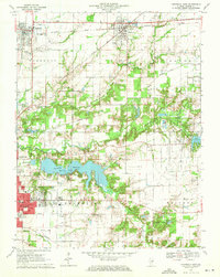
 1985 Carlyle Lake1985 Print · USGSSouthwestern Illinois in the mid-eighties shows a landscape of growing commuter suburbs and massive water management projects. Genealogists and historians can locate family plots at Lakeview Memorial Gardens Cem or trace the early footprint of Southern Illinois Univ (Edwardsville).2 unique versions available
 - 1985 Map of Pinckneyville
 1985 Pinckneyville1985 Print · USGSSouthern Illinois in the mid-eighties shows a landscape of prairie farms, coal extraction, and vital rail corridors. Researchers can trace the rail-side growth of Venedy Station and New Memphis Station or locate landmarks like St Libory Church and Memorial Gardens Cem.2 unique versions available
End of results
Showing maps 1-12 of 12
Top cities near Centralia
- Mount Vernon historical maps
- Salem historical maps
- Carlyle historical maps
- Sandoval historical maps
- Central City historical maps
- Odin historical maps
See more
Frequently asked questions
- What are the different types of historical maps available for Centralia?
- What is the oldest map of Centralia?
- Where can I purchase historical maps of Centralia for my home or office?
- Where can I download high-res historical maps of Centralia?
- Are there historical topographic maps available for Centralia?
- Is there historical aerial imagery available for Centralia?
- Where are historical maps of Centralia sourced from?