1930s Maps of Marshall County, Illinois
Explore 9 historic maps of Marshall County from the 1930s. These maps offer a rare glimpse into what life looked like during the 1930s — showing old roads, neighborhoods, homes, and landmarks that have changed or disappeared over time.
Whether you're researching your family's past, planning a metal detecting trip, or studying how Marshall County's landscape evolved across the 1930s, these high-resolution maps are a powerful tool for exploring the history of this region.
- Focus on a specific era: All maps on this page are from the 1930s, giving you a focused view of this time period.
- See what’s changed: Compare century-old streets, trails, and buildings to today's modern landscape using overlays and satellite layers.
- Research with precision: Use these maps for genealogy, historical research, land use analysis, or educational projects.
- View, download, or print: Maps are fully viewable online in high resolution, and can be downloaded or printed for your own records.
Start exploring Marshall County's history through authentic maps from the 1930s. This is your window into the past.
Marshall County, IL maps
(9)- 1932 Map of Dunlap
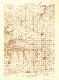
 1932 Dunlap1932 Print · USGSNorth of Peoria in the late nineteenth century, the prairie landscape was being reshaped by a dense network of competing rail lines. Trace old homesteads and vanished stops like Orange Prairie and Wady Petra along the Illinois River bluffs.
 - 1933 Map of Dunlap
 1933 Dunlap1933 Print · USGSPeoria County's agricultural heartland and river bluffs are captured here between the world wars, when coal mines and early airfields sat alongside rural hamlets. Family historians can locate dozens of country schools, family-named cemeteries like Dickison Cem, and the historic Evans Mill Bridge.
 - 1933 Map of Lacon
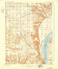
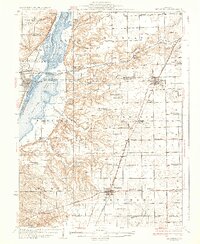
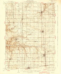
 1933 Lacon1933 Print · USGSThe Illinois River valley in the early 1930s reveals a complex network of backwater lakes and rail-dependent towns. Researchers can locate family landmarks like St Joseph Cem, the Whitefield Town Hall, and dozens of rural schoolhouses such as Brush College Sch.3 unique versions available
 - 1933 Map of Camp Grove
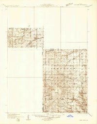 1933 Camp Grove1933 Print · USGSThe Illinois prairie between Bradford and Camp Grove in the 1930s reveals a landscape of vanished rural schools and early rail lines. Genealogists can trace family footprints at St Johns Cem, Union Ch, or the small settlement of Red Town.
 - 1934 Map of Wenona
 1934 Wenona1934 Print · USGSThe crossroads of Marshall, Putnam, and La Salle counties are captured here in the mid-1930s, revealing a landscape defined by railroad junctions and rural school districts. Genealogists can locate family-named landmarks like Hullinger Sch and Beckwith Sch, or trace the tracks of the Illinois Central through Wenona.2 unique versions available
 - 1937 Map of Metamora
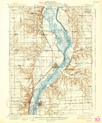
 1937 Metamora1937 Print · USGSThe Illinois River valley and its complex network of sloughs and lakes define this Depression-era portrait of Woodford and Marshall counties. You can trace early 20th-century rural life through dozens of named schoolhouses like Hytex Sch and local landmarks such as Lourdes Ch or the County Home.3 unique versions available
 - 1937 Map of Dunlap
 1937 Dunlap1937 Print · USGSPeoria County and its river bluffs are shown in the 1930s as a vital transportation hub of railroads and early airfields. Researchers can trace rural lineages through the many schools and burial grounds like Lawn Ridge Cem, Prospect Cem, and Hazel Dell Sch.3 unique versions available
 - 1937 Map of Lacon
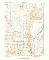
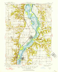
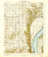
 1937 Lacon1937 Print · USGSMid-century life along the Illinois River valley reveals a landscape of thriving river towns and rural school districts in the 1930s. Trace the vanished local footprints of Whitefield Town Hall, the Alton RR corridor, and family-named sites like Bonham Cem.2 unique versions available
 - 1939 Map of Wenona
 1939 Wenona1939 Print · USGSNorth-central Illinois agricultural and rail hubs are captured here in the late 1930s as steam-era infrastructure reached its peak. Researchers can locate dozens of country schools and trace the tracks of the Illinois Central through Wenona and Tonica.2 unique versions available
End of results
Showing maps 1-9 of 9
Top cities of Marshall County
- Henry historical maps
- Lacon historical maps
- Evans historical maps
- Toluca historical maps
- Sparland historical maps
- Hopewell historical maps
See more
Frequently asked questions
- What are the different types of historical maps available for Marshall County?
- What is the oldest map of Marshall County?
- Where can I purchase historical maps of Marshall County for my home or office?
- Where can I download high-res historical maps of Marshall County?
- Are there historical topographic maps available for Marshall County?
- Is there historical aerial imagery available for Marshall County?
- Where are historical maps of Marshall County sourced from?