1980s Maps of Bloomington, Illinois
Explore 10 historic maps of Bloomington from the 1980s. These maps offer a rare glimpse into what life looked like during the 1980s — showing old roads, neighborhoods, homes, and landmarks that have changed or disappeared over time.
Whether you're researching your family's past, planning a metal detecting trip, or studying how Bloomington's landscape evolved across the 1980s, these high-resolution maps are a powerful tool for exploring the history of this region.
- Focus on a specific era: All maps on this page are from the 1980s, giving you a focused view of this time period.
- See what’s changed: Compare century-old streets, trails, and buildings to today's modern landscape using overlays and satellite layers.
- Research with precision: Use these maps for genealogy, historical research, land use analysis, or educational projects.
- View, download, or print: Maps are fully viewable online in high resolution, and can be downloaded or printed for your own records.
Start exploring Bloomington's history through authentic maps from the 1980s. This is your window into the past.
Bloomington, IL maps
(10)- 1981 Map of Holder
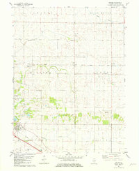 1981 Holder1981 Print · USGSMcLean County, Illinois, remains a quintessential rail-and-creek landscape during the early 1980s. Local researchers can trace family landmarks and transport hubs from the village of Downs to the rural Benjaminville Cem and the NORFOLK AND WESTERN rail line.2 unique versions available
 - 1981 Map of Bloomington West
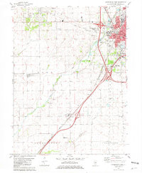 1981 Bloomington West1981 Print · USGSMcLean County in the early eighties shows the expansion of the Bloomington-Normal area into the surrounding prairie. Researchers can trace the layout of old burial grounds like Twin Grove Cem and Scogin Hill Cem or locate rural landmarks such as Shirley and Covell.
 - 1981 Map of Bloomington East
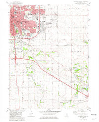 1981 Bloomington East1981 Print · USGSBloomington and Normal expansion is captured here in the early eighties as the urban grid meets the central Illinois prairie. Trace local history at Illinois Wesleyan University, or locate family sites at Evergreen Memorial Cemetery and the County Farm.
 - 1981 Map of Normal East
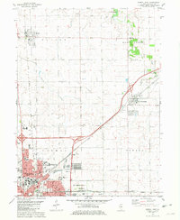 1981 Normal East1981 Print · USGSCentral Illinois growth reaches toward Hudson and Towanda in the early eighties as urban borders expand near the university campus. Genealogists can trace family plots at Bishop Cem or Havens Cem and locate landmarks like the Soldiers and Sailors State Childrens Home.
 - 1985 Map of Peoria
 1985 Peoria1985 Print · USGSThe Illinois River valley and the Tri-County area are captured here in the mid-1980s as industry and infrastructure reshaped the heart of the state. Researchers can trace the grounds of Jubilee College, locate the Stark Mine near Elmwood, or follow the busy tracks of the Norfolk and Western Railroad.
 - 1985 Map of Fairbury
 1985 Fairbury1985 Print · USGSCentral Illinois in the mid-1980s reveals a landscape shaped by the Illinois Central Gulf rail network and the Vermilion River basin. Trace the roots of local communities from Fairbury to Pontiac, and locate landmarks like the State Correctional Center and High Chapel.2 unique versions available
 - 1985 Map of Lincoln
 1985 Lincoln1985 Print · USGSMid-century Illinois comes to life in this survey of Logan and Mason counties as the interstate era reshapes the prairie. Genealogists and historians can trace rail-town development from San Jose to Kenney or locate landmarks like Rose Hill Cem and Funks Grove.
 - 1985 Map of Champaign, 1986 Print
 1985 Champaign1986 Print · USGSThe Illinois prairie comes alive in this mid-eighties survey of the vital rail corridor between Bloomington and Champaign. Genealogists and historians can trace the development of township hubs like Saybrook and Bellflower or locate Chanute Air Force Base and the Sangamon River.2 unique versions available
 - 1989 Map of Lincoln
 1989 Lincoln1989 Print · USGSCentral Illinois in the late eighties remains a landscape of productive prairie and vital river arteries. Genealogists and local historians can trace rural family landmarks like Rose Hill Cem, identify early aviation at Logan County Airport, or follow the Illinois Central Gulf Railroad through towns like Atlanta and Lincoln.
 - 1989 Map of Peoria
 1989 Peoria1989 Print · USGSThe Illinois River valley thrived as a regional center of industry, education, and transport during the late eighties. Researchers can trace the extensive rail networks of the Peoria and Pekin Union Railway or locate landmarks like Bradley University and the Peoria Air National Guard Base.
End of results
Showing maps 1-10 of 10
Top cities near Bloomington
- Normal historical maps
- Randolph historical maps
- Le Roy historical maps
- Heyworth historical maps
- Lexington historical maps
- Hudson historical maps
See more
Top neighborhoods of Bloomington
- Park Place on the Creek II historical maps
- Elm Point Apartments historical maps
- Danbury Court historical maps
- Fox Lake historical maps
- Lake Ridge historical maps
- GrandView Estates historical maps
See more
Frequently asked questions
- What are the different types of historical maps available for Bloomington?
- What is the oldest map of Bloomington?
- Where can I purchase historical maps of Bloomington for my home or office?
- Where can I download high-res historical maps of Bloomington?
- Are there historical topographic maps available for Bloomington?
- Is there historical aerial imagery available for Bloomington?
- Where are historical maps of Bloomington sourced from?