1920s Maps of Honey Bend, Illinois
Explore 2 historic maps of Honey Bend from the 1920s. These maps offer a rare glimpse into what life looked like during the 1920s — showing old roads, neighborhoods, homes, and landmarks that have changed or disappeared over time.
Whether you're researching your family's past, planning a metal detecting trip, or studying how Honey Bend's landscape evolved across the 1920s, these high-resolution maps are a powerful tool for exploring the history of this region.
- Focus on a specific era: All maps on this page are from the 1920s, giving you a focused view of this time period.
- See what’s changed: Compare century-old streets, trails, and buildings to today's modern landscape using overlays and satellite layers.
- Research with precision: Use these maps for genealogy, historical research, land use analysis, or educational projects.
- View, download, or print: Maps are fully viewable online in high resolution, and can be downloaded or printed for your own records.
Start exploring Honey Bend's history through authentic maps from the 1920s. This is your window into the past.
Honey Bend, IL maps
(2)- 1923 Map of Raymond, 1965 Print
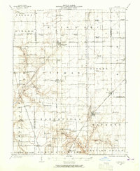 1923 Raymond1965 Print · USGSCentral Illinois at the start of the 1920s showcases a high-density rural network of railroads and country schoolhouses. Researchers can trace family history at sites like the Studebaker School, Bethel Church, and old settlements like Thomasville or Farmersville.2 unique versions available
 - 1925 Map of Raymond
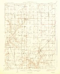 1925 Raymond1925 Print · USGSIn the mid-1920s, this Montgomery County landscape was a thriving rail-and-farm network centered on Raymond and Harvel. Genealogists can trace family roots through dozens of local landmarks like South Bois d'Arc School, Providence Church, and Honey Bend.2 unique versions available
End of results
Showing maps 1-2 of 2
Top cities near Honey Bend
- Litchfield historical maps
- Hillsboro historical maps
- Carlinville historical maps
- Gillespie historical maps
- Girard historical maps
- Mount Olive historical maps
See more
Frequently asked questions
- What are the different types of historical maps available for Honey Bend?
- What is the oldest map of Honey Bend?
- Where can I purchase historical maps of Honey Bend for my home or office?
- Where can I download high-res historical maps of Honey Bend?
- Are there historical topographic maps available for Honey Bend?
- Is there historical aerial imagery available for Honey Bend?
- Where are historical maps of Honey Bend sourced from?