1940s Maps of Moweaqua, Illinois
Explore 1 historic maps of Moweaqua from the 1940s. These maps offer a rare glimpse into what life looked like during the 1940s — showing old roads, neighborhoods, homes, and landmarks that have changed or disappeared over time.
Whether you're researching your family's past, planning a metal detecting trip, or studying how Moweaqua's landscape evolved across the 1940s, these high-resolution maps are a powerful tool for exploring the history of this region.
- Focus on a specific era: All maps on this page are from the 1940s, giving you a focused view of this time period.
- See what’s changed: Compare century-old streets, trails, and buildings to today's modern landscape using overlays and satellite layers.
- Research with precision: Use these maps for genealogy, historical research, land use analysis, or educational projects.
- View, download, or print: Maps are fully viewable online in high resolution, and can be downloaded or printed for your own records.
Start exploring Moweaqua's history through authentic maps from the 1940s. This is your window into the past.
Moweaqua, IL maps
(1)- 1949 Map of Dalton City
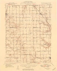 1949 Dalton City1949 Print · USGSCentral Illinois agriculture and rail transit are documented here just after the war, showing the dense network of one-room schools and country churches. Genealogists can locate family landmarks like Sanner Chapel, New Hope Cem, and Penn Consolidated Sch.2 unique versions available
End of results
Showing maps 1-1 of 1
Top cities near Moweaqua
- Decatur historical maps
- Taylorville historical maps
- Pana historical maps
- Mount Zion historical maps
- Shelbyville historical maps
- Long Creek historical maps
See more
Frequently asked questions
- What are the different types of historical maps available for Moweaqua?
- What is the oldest map of Moweaqua?
- Where can I purchase historical maps of Moweaqua for my home or office?
- Where can I download high-res historical maps of Moweaqua?
- Are there historical topographic maps available for Moweaqua?
- Is there historical aerial imagery available for Moweaqua?
- Where are historical maps of Moweaqua sourced from?