1910s Maps of Lost Nation, Taylor Township
Explore 1 historic maps of Lost Nation from the 1910s. These maps offer a rare glimpse into what life looked like during the 1910s — showing old roads, neighborhoods, homes, and landmarks that have changed or disappeared over time.
Whether you're researching your family's past, planning a metal detecting trip, or studying how Lost Nation's landscape evolved across the 1910s, these high-resolution maps are a powerful tool for exploring the history of this region.
- Focus on a specific era: All maps on this page are from the 1910s, giving you a focused view of this time period.
- See what’s changed: Compare century-old streets, trails, and buildings to today's modern landscape using overlays and satellite layers.
- Research with precision: Use these maps for genealogy, historical research, land use analysis, or educational projects.
- View, download, or print: Maps are fully viewable online in high resolution, and can be downloaded or printed for your own records.
Start exploring Lost Nation's history through authentic maps from the 1910s. This is your window into the past.
Lost Nation, Taylor Township maps
(1)- 1918 Map of Dixon
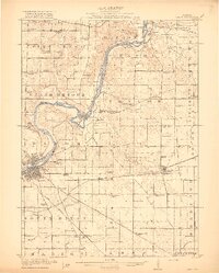 1918 Dixon1918 Print · USGSLee and Ogle Counties are captured at a pivotal moment during the First World War when the rural schoolhouse system was at its peak. Genealogists can trace family footprints across townships to landmarks like Grand Detour, Pennsylvania Corners, and the White Temple School.3 unique versions available
End of results
Showing maps 1-1 of 1
Top cities near Lost Nation
- Dixon historical maps
- Oregon historical maps
- Byron historical maps
- Mount Morris historical maps
- Palmyra historical maps
- Amboy historical maps
See more
Frequently asked questions
- What are the different types of historical maps available for Lost Nation?
- What is the oldest map of Lost Nation?
- Where can I purchase historical maps of Lost Nation for my home or office?
- Where can I download high-res historical maps of Lost Nation?
- Are there historical topographic maps available for Lost Nation?
- Is there historical aerial imagery available for Lost Nation?
- Where are historical maps of Lost Nation sourced from?