1970s Maps of Perry County, Illinois
Explore 7 historic maps of Perry County from the 1970s. These maps offer a rare glimpse into what life looked like during the 1970s — showing old roads, neighborhoods, homes, and landmarks that have changed or disappeared over time.
Whether you're researching your family's past, planning a metal detecting trip, or studying how Perry County's landscape evolved across the 1970s, these high-resolution maps are a powerful tool for exploring the history of this region.
- Focus on a specific era: All maps on this page are from the 1970s, giving you a focused view of this time period.
- See what’s changed: Compare century-old streets, trails, and buildings to today's modern landscape using overlays and satellite layers.
- Research with precision: Use these maps for genealogy, historical research, land use analysis, or educational projects.
- View, download, or print: Maps are fully viewable online in high resolution, and can be downloaded or printed for your own records.
Start exploring Perry County's history through authentic maps from the 1970s. This is your window into the past.
Perry County, IL maps
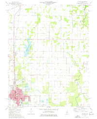
(7)- 1974 Map of Winkle, 1978 Print
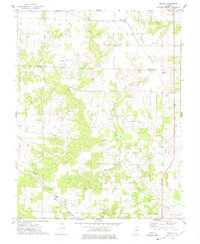 1974 Winkle1978 Print · USGSPerry County and Washington County are captured in the mid-1970s, showing a rural landscape defined by the Illinois Central Gulf railroad. Researchers can locate family landmarks like Pilot Knob Cem, Bethel Ch, and the small settlement of Winkle.
 - 1974 Map of Pinckneyville, 1978 Print
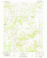
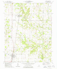
 1974 Pinckneyville1978 Print · USGSPinckneyville and the surrounding Perry County coalfields are captured here in the mid-seventies, showing a landscape shaped by rail and industry. Genealogists can trace family names at Mueller Hill Cemetery or visit rural centers like St Bruno School and Layfield.2 unique versions available
 - 1974 Map of Pyatts, 1978 Print
 1974 Pyatts1978 Print · USGSPerry County's mining and rail corridors are captured in the mid-1970s as surface extraction reshaped the landscape around Pinckneyville. Genealogists and local historians can locate community sites such as Cudgetown, School No 204, and the Sacred Heart Cem.2 unique versions available
 - 1974 Map of Todds Mill, 1978 Print
 1974 Todds Mill1978 Print · USGSPerry and Washington counties in the mid-1970s are defined by the winding waters of Beaucoup Creek and the small settlement of Todds Mill. Genealogists can trace local roots through several landmarks including Antioch Cem, Cross Ch, and Round Prairie Cem.
 - 1975 Map of Du Quoin, 1977 Print
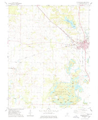
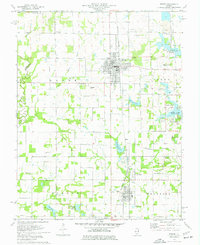
 1975 Du Quoin1977 Print · USGSMid-century Perry County is defined here by the intersection of industrial energy and small-town life. Researchers can trace the layout of Du Quoin during the 1970s, locating the Tamaroa South Oil Field, Browning Hospital, and several rural burial grounds.
 - 1975 Map of Tamaroa, 1977 Print
 1975 Tamaroa1977 Print · USGSThe rail-and-river landscape of Perry and Washington Counties comes to life in this mid-seventies survey of the Illinois interior. Genealogists and historians can trace the Tamaroa Oil Field, the village of Tamaroa, and local landmarks like Antioch Cem and Curlee Cem.
 - 1975 Map of Sesser, 1977 Print
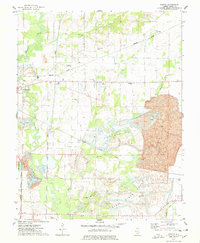
 1975 Sesser1977 Print · USGSDuring the mid-seventies, this area of Franklin County saw the industrial mining of the Old Ben No 21 Mine meet the growing waters of Rend Lake. Genealogists and local historians can trace rural cemeteries like Maple Hill Cem and Youngblood Cem alongside the BURLINGTON NORTHERN rail line.
End of results
Showing maps 1-7 of 7
Top cities of Perry County
- Du Quoin historical maps
- Pinckneyville historical maps
- Tamaroa historical maps
- Willisville historical maps
- Cutler historical maps
Frequently asked questions
- What are the different types of historical maps available for Perry County?
- What is the oldest map of Perry County?
- Where can I purchase historical maps of Perry County for my home or office?
- Where can I download high-res historical maps of Perry County?
- Are there historical topographic maps available for Perry County?
- Is there historical aerial imagery available for Perry County?
- Where are historical maps of Perry County sourced from?