1930s Maps of Shinn, Illinois
Explore 2 historic maps of Shinn from the 1930s. These maps offer a rare glimpse into what life looked like during the 1930s — showing old roads, neighborhoods, homes, and landmarks that have changed or disappeared over time.
Whether you're researching your family's past, planning a metal detecting trip, or studying how Shinn's landscape evolved across the 1930s, these high-resolution maps are a powerful tool for exploring the history of this region.
- Focus on a specific era: All maps on this page are from the 1930s, giving you a focused view of this time period.
- See what’s changed: Compare century-old streets, trails, and buildings to today's modern landscape using overlays and satellite layers.
- Research with precision: Use these maps for genealogy, historical research, land use analysis, or educational projects.
- View, download, or print: Maps are fully viewable online in high resolution, and can be downloaded or printed for your own records.
Start exploring Shinn's history through authentic maps from the 1930s. This is your window into the past.
Shinn, IL maps
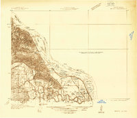
(2)- 1931 Map of Barry
 1931 Barry1931 Print · USGSPike County bottomlands along the Mississippi River are shown here in the late twenties and early thirties, just as drainage projects transformed the landscape. Genealogists and local historians can trace rural school locations like Guss Sch and Munger Sch, or find family burials at Money Cem and Blackjack Cem.
 - 1936 Map of Barry
 1936 Barry1936 Print · USGSThe Mississippi River valley in the mid-1930s reveals a complex network of island chutes and railroad settlements. Genealogists and historians can trace old river crossings like Stouts Ford and find vanished local school districts such as Love Sch and Hawk Creek Sch.2 unique versions available
End of results
Showing maps 1-2 of 2
Top cities near Shinn
- Quincy historical maps
- Hannibal historical maps
- Louisiana historical maps
- Barry historical maps
- Payson historical maps
- New London historical maps
See more
Frequently asked questions
- What are the different types of historical maps available for Shinn?
- What is the oldest map of Shinn?
- Where can I purchase historical maps of Shinn for my home or office?
- Where can I download high-res historical maps of Shinn?
- Are there historical topographic maps available for Shinn?
- Is there historical aerial imagery available for Shinn?
- Where are historical maps of Shinn sourced from?