1990s Maps of Hartsville, Illinois
Explore 1 historic maps of Hartsville from the 1990s. These maps offer a rare glimpse into what life looked like during the 1990s — showing old roads, neighborhoods, homes, and landmarks that have changed or disappeared over time.
Whether you're researching your family's past, planning a metal detecting trip, or studying how Hartsville's landscape evolved across the 1990s, these high-resolution maps are a powerful tool for exploring the history of this region.
- Focus on a specific era: All maps on this page are from the 1990s, giving you a focused view of this time period.
- See what’s changed: Compare century-old streets, trails, and buildings to today's modern landscape using overlays and satellite layers.
- Research with precision: Use these maps for genealogy, historical research, land use analysis, or educational projects.
- View, download, or print: Maps are fully viewable online in high resolution, and can be downloaded or printed for your own records.
Start exploring Hartsville's history through authentic maps from the 1990s. This is your window into the past.
Hartsville, IL maps
(1)- 1996 Map of Herod, 1998 Print
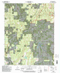 1996 Herod1998 Print · USGSThe Illinois Ozarks come alive in this mid-nineties survey of the Shawnee National Forest. Researchers can trace rural lineages through numerous remote burial sites like Old Grand Pierre Cem and explore the geography of the Empire Mine or One Horse Gap.
End of results
Showing maps 1-1 of 1
Top cities near Hartsville
- Harrisburg historical maps
- Carrier Mills historical maps
- Rosiclare historical maps
- Equality historical maps
- Golconda historical maps
- Elizabethtown historical maps
See more
Frequently asked questions
- What are the different types of historical maps available for Hartsville?
- What is the oldest map of Hartsville?
- Where can I purchase historical maps of Hartsville for my home or office?
- Where can I download high-res historical maps of Hartsville?
- Are there historical topographic maps available for Hartsville?
- Is there historical aerial imagery available for Hartsville?
- Where are historical maps of Hartsville sourced from?