1950s Maps of Fairmont City, Illinois
Explore 2 historic maps of Fairmont City from the 1950s. These maps offer a rare glimpse into what life looked like during the 1950s — showing old roads, neighborhoods, homes, and landmarks that have changed or disappeared over time.
Whether you're researching your family's past, planning a metal detecting trip, or studying how Fairmont City's landscape evolved across the 1950s, these high-resolution maps are a powerful tool for exploring the history of this region.
- Focus on a specific era: All maps on this page are from the 1950s, giving you a focused view of this time period.
- See what’s changed: Compare century-old streets, trails, and buildings to today's modern landscape using overlays and satellite layers.
- Research with precision: Use these maps for genealogy, historical research, land use analysis, or educational projects.
- View, download, or print: Maps are fully viewable online in high resolution, and can be downloaded or printed for your own records.
Start exploring Fairmont City's history through authentic maps from the 1950s. This is your window into the past.
Fairmont City, IL maps
(2)- 1954 Map of Granite City, 1958 Print
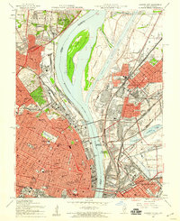 1954 Granite City1958 Print · USGSThe mid-century riverfront industrial landscape comes alive here where Missouri and Illinois meet at the Mississippi. Researchers can trace historic neighborhoods and landmarks from Busch Stadium to the sprawling Calvary Cemetery and the Chain of Rocks Canal.6 unique versions available
 - 1954 Map of Monks Mound, 1959 Print
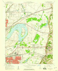 1954 Monks Mound1959 Print · USGSThe Madison County bottomlands in the mid-1950s show a fascinating landscape of prehistoric earthworks and modern rail yards. Genealogists and historians can trace family-named schools and sites like Bullfrog Station Sch, Moellenbrocks, and the massive Monks Mound.5 unique versions available
End of results
Showing maps 1-2 of 2
Top cities near Fairmont City
- St. Louis historical maps
- Florissant historical maps
- Belleville historical maps
- Oakville historical maps
- University City historical maps
- O'Fallon historical maps
See more
Top neighborhoods of Fairmont City
Frequently asked questions
- What are the different types of historical maps available for Fairmont City?
- What is the oldest map of Fairmont City?
- Where can I purchase historical maps of Fairmont City for my home or office?
- Where can I download high-res historical maps of Fairmont City?
- Are there historical topographic maps available for Fairmont City?
- Is there historical aerial imagery available for Fairmont City?
- Where are historical maps of Fairmont City sourced from?