1990s Maps of Estates at Lincoln Farm, O'Fallon
Explore 2 historic maps of Estates at Lincoln Farm from the 1990s. These maps offer a rare glimpse into what life looked like during the 1990s — showing old roads, neighborhoods, homes, and landmarks that have changed or disappeared over time.
Whether you're researching your family's past, planning a metal detecting trip, or studying how Estates at Lincoln Farm's landscape evolved across the 1990s, these high-resolution maps are a powerful tool for exploring the history of this region.
- Focus on a specific era: All maps on this page are from the 1990s, giving you a focused view of this time period.
- See what’s changed: Compare century-old streets, trails, and buildings to today's modern landscape using overlays and satellite layers.
- Research with precision: Use these maps for genealogy, historical research, land use analysis, or educational projects.
- View, download, or print: Maps are fully viewable online in high resolution, and can be downloaded or printed for your own records.
Start exploring Estates at Lincoln Farm's history through authentic maps from the 1990s. This is your window into the past.
Estates at Lincoln Farm, O'Fallon maps
(2)- 1991 Map of O'Fallon
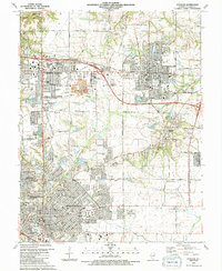 1991 O'Fallon1991 Print · USGSSt. Clair County experiences significant suburban growth in the early nineties as residential developments expand around traditional industry. Trace family roots and local history through Messenger Cem, the tracks of the Southern Railway, and Shiloh Station.2 unique versions available
 - 1991 Map of Collinsville
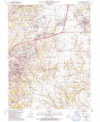 1991 Collinsville1991 Print · USGSThe Collinsville and Troy area comes alive in the early nineties as suburban neighborhoods began to weave through the older rural landscape. Researchers can trace family sites at St Pauls Cem or locate community landmarks like Maryville Sch and Troy Crossing.
End of results
Showing maps 1-2 of 2
Frequently asked questions
- What are the different types of historical maps available for Estates at Lincoln Farm?
- What is the oldest map of Estates at Lincoln Farm?
- Where can I purchase historical maps of Estates at Lincoln Farm for my home or office?
- Where can I download high-res historical maps of Estates at Lincoln Farm?
- Are there historical topographic maps available for Estates at Lincoln Farm?
- Is there historical aerial imagery available for Estates at Lincoln Farm?
- Where are historical maps of Estates at Lincoln Farm sourced from?