1930s Maps of Forest Hills, O'Fallon
Explore 2 historic maps of Forest Hills from the 1930s. These maps offer a rare glimpse into what life looked like during the 1930s — showing old roads, neighborhoods, homes, and landmarks that have changed or disappeared over time.
Whether you're researching your family's past, planning a metal detecting trip, or studying how Forest Hills's landscape evolved across the 1930s, these high-resolution maps are a powerful tool for exploring the history of this region.
- Focus on a specific era: All maps on this page are from the 1930s, giving you a focused view of this time period.
- See what’s changed: Compare century-old streets, trails, and buildings to today's modern landscape using overlays and satellite layers.
- Research with precision: Use these maps for genealogy, historical research, land use analysis, or educational projects.
- View, download, or print: Maps are fully viewable online in high resolution, and can be downloaded or printed for your own records.
Start exploring Forest Hills's history through authentic maps from the 1930s. This is your window into the past.
Forest Hills, O'Fallon maps
(2)- 1937 Map of Collinsville
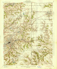 1937 Collinsville1937 Print · USGSSouthwestern Illinois thrives in the mid-1930s as a hub of rail traffic and coal-country commerce. Genealogists and local historians can trace family locations near Chinatown, Donkville, and numerous country schools like Bethel Sch or Spring Valley Sch.2 unique versions available
 - 1937 Map of O'Fallon
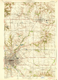 1937 O'Fallon1937 Print · USGSSt. Clair County's coal and rail landscape is on full display during the late 1930s. Genealogists and historians can trace rail depots like Shiloh Sta, local mines including St Ellen Mine, and numerous country schools such as Whiteside Sch.2 unique versions available
End of results
Showing maps 1-2 of 2
Frequently asked questions
- What are the different types of historical maps available for Forest Hills?
- What is the oldest map of Forest Hills?
- Where can I purchase historical maps of Forest Hills for my home or office?
- Where can I download high-res historical maps of Forest Hills?
- Are there historical topographic maps available for Forest Hills?
- Is there historical aerial imagery available for Forest Hills?
- Where are historical maps of Forest Hills sourced from?