1900s (20th Century) Maps of Illiopolis, Illinois
Explore 7 historic maps of Illiopolis from the 1900s (20th Century). These maps offer a rare glimpse into what life looked like during the 1900s — showing old roads, neighborhoods, homes, and landmarks that have changed or disappeared over time.
Whether you're researching your family's past, planning a metal detecting trip, or studying how Illiopolis's landscape evolved across the 1900s, these high-resolution maps are a powerful tool for exploring the history of this region.
- Focus on a specific era: All maps on this page are from the 1900s, giving you a focused view of this time period.
- See what’s changed: Compare century-old streets, trails, and buildings to today's modern landscape using overlays and satellite layers.
- Research with precision: Use these maps for genealogy, historical research, land use analysis, or educational projects.
- View, download, or print: Maps are fully viewable online in high resolution, and can be downloaded or printed for your own records.
Start exploring Illiopolis's history through authentic maps from the 1900s. This is your window into the past.
Illiopolis, IL maps
(7)- 1954 Map of Niantic, 1955 Print
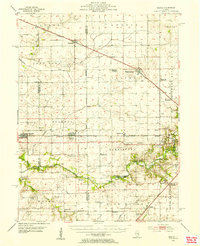 1954 Niantic1955 Print · USGSMid-century Macon County is defined here by its bustling rail corridors and the winding Sangamon River. Researchers can trace old family names at Lake Bank Cem or locate forgotten stops like Wyckles Corners and Bulldog Crossing.3 unique versions available
 - 1954 Map of Mechanicsburg, 1955 Print
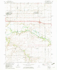
 1954 Mechanicsburg1955 Print · USGSSangamon and Logan counties are shown here during the mid-fifties as the railroad era began to give way to modern highways. Genealogists can trace family names at Pickrell Cem and Steenbergen Cem or locate the North Side Sch (Abandoned).2 unique versions available
 - 1958 Map of Decatur, 1971 Print
 1958 Decatur1971 Print · USGSCentral Illinois in the mid-twentieth century shows a landscape defined by industrial rail hubs and the creation of large reservoirs. Researchers can trace historic corridors like the Penn Central or locate landmarks such as Lincoln Log Cabin State Park and Lake Springfield.3 unique versions available
 - 1961 Map of Decatur
 1961 Decatur1961 Print · USGSCentral Illinois in the late fifties was a bustling corridor of rail lines and prairie commerce centered on the state capital. Genealogists and historians can trace the intricate connections between Springfield, Decatur, and dozens of smaller settlements like Nokomis and Arcola.2 unique versions available
 - 1982 Map of Niantic, 1983 Print
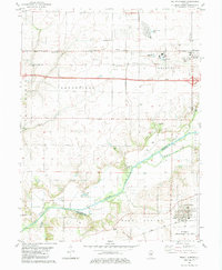
 1982 Niantic1983 Print · USGSNiantic and Illiopolis sit at the heart of this early 1980s landscape, where the Sangamon River valley meets a bustling rail corridor. Researchers can locate generational sites like Hunter Cem, Long Point Ch, and the rural outpost of Osbernville.
 - 1982 Map of Mount Auburn, 1983 Print
 1982 Mount Auburn1983 Print · USGSAgricultural and industrial life meet along the Sangamon River during the early eighties. Genealogists and local historians can trace family plots at Riverside Cem or study the rail operations of the Norfolk and Western and Baltimore and Ohio.
 - 1985 Map of Springfield
 1985 Springfield1985 Print · USGSCentral Illinois during the mid-eighties shows a landscape of growing state capital influence and deep historical roots. Genealogists and historians can trace family sites near Oak Ridge Cem or follow the path of the Sangamon River past Williamsville and Riverton.2 unique versions available
End of results
Showing maps 1-7 of 7
Top cities near Illiopolis
- Decatur historical maps
- Moweaqua historical maps
- Mount Pulaski historical maps
- Harristown historical maps
- Warrensburg historical maps
- Edinburg historical maps
See more
Frequently asked questions
- What are the different types of historical maps available for Illiopolis?
- What is the oldest map of Illiopolis?
- Where can I purchase historical maps of Illiopolis for my home or office?
- Where can I download high-res historical maps of Illiopolis?
- Are there historical topographic maps available for Illiopolis?
- Is there historical aerial imagery available for Illiopolis?
- Where are historical maps of Illiopolis sourced from?