1940s Maps of Cowden, Illinois
Explore 4 historic maps of Cowden from the 1940s. These maps offer a rare glimpse into what life looked like during the 1940s — showing old roads, neighborhoods, homes, and landmarks that have changed or disappeared over time.
Whether you're researching your family's past, planning a metal detecting trip, or studying how Cowden's landscape evolved across the 1940s, these high-resolution maps are a powerful tool for exploring the history of this region.
- Focus on a specific era: All maps on this page are from the 1940s, giving you a focused view of this time period.
- See what’s changed: Compare century-old streets, trails, and buildings to today's modern landscape using overlays and satellite layers.
- Research with precision: Use these maps for genealogy, historical research, land use analysis, or educational projects.
- View, download, or print: Maps are fully viewable online in high resolution, and can be downloaded or printed for your own records.
Start exploring Cowden's history through authentic maps from the 1940s. This is your window into the past.
Cowden, IL maps
(4)- 1941 Map of St. Elmo, 1958 Print
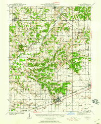 1941 St. Elmo1958 Print · USGSThe Illinois counties of Fayette, Shelby, and Effingham are mapped here in the early 1940s at the height of their rail-and-refinery era. Genealogists and historians can trace numerous country schools like Martin Box Sch and churches like Crums Chapel near the Carter Refinery.2 unique versions available
 - 1942 Map of Shelbyville, 1958 Print
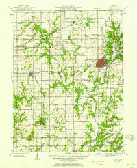 1942 Shelbyville1958 Print · USGSShelby County at the start of the 1940s reveals a landscape defined by the winding Kaskaskia River and its many bridge crossings. Researchers can trace family history through dozens of rural landmarks like Williamsburg Hill, Glenwood Cem, and Sandy Hill Sch.2 unique versions available
 - 1945 Map of St. Elmo
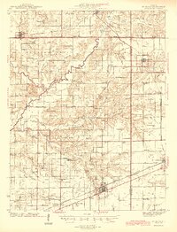 1945 St. Elmo1945 Print · USGSFayette and Effingham counties are seen here in the 1940s at a peak of rail and river industry. Genealogists and historians can trace family locations near Saint Elmo, locate the Carter Refinery, or find rural landmarks like Crums Chapel and Meyers Cem.2 unique versions available
 - 1946 Map of Shelbyville
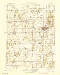 1946 Shelbyville1946 Print · USGSMid-century Shelby County centers on the rail-and-river hub of Shelbyville during an era of thriving rural townships. Genealogists can trace hundreds of family sites, from the County Poor Farm to Ragweed Sch and Gallagher Chapel Cem.2 unique versions available
End of results
Showing maps 1-4 of 4
Top cities near Cowden
- Pana historical maps
- Shelbyville historical maps
- Altamont historical maps
- St. Elmo historical maps
- Saint Elmo historical maps
- Stewardson historical maps
See more
Frequently asked questions
- What are the different types of historical maps available for Cowden?
- What is the oldest map of Cowden?
- Where can I purchase historical maps of Cowden for my home or office?
- Where can I download high-res historical maps of Cowden?
- Are there historical topographic maps available for Cowden?
- Is there historical aerial imagery available for Cowden?
- Where are historical maps of Cowden sourced from?