1900s (20th Century) Maps of Cowden, Illinois
Explore 10 historic maps of Cowden from the 1900s (20th Century). These maps offer a rare glimpse into what life looked like during the 1900s — showing old roads, neighborhoods, homes, and landmarks that have changed or disappeared over time.
Whether you're researching your family's past, planning a metal detecting trip, or studying how Cowden's landscape evolved across the 1900s, these high-resolution maps are a powerful tool for exploring the history of this region.
- Focus on a specific era: All maps on this page are from the 1900s, giving you a focused view of this time period.
- See what’s changed: Compare century-old streets, trails, and buildings to today's modern landscape using overlays and satellite layers.
- Research with precision: Use these maps for genealogy, historical research, land use analysis, or educational projects.
- View, download, or print: Maps are fully viewable online in high resolution, and can be downloaded or printed for your own records.
Start exploring Cowden's history through authentic maps from the 1900s. This is your window into the past.
Cowden, IL maps
(10)- 1941 Map of St. Elmo, 1958 Print
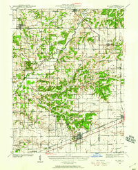 1941 St. Elmo1958 Print · USGSThe Illinois counties of Fayette, Shelby, and Effingham are mapped here in the early 1940s at the height of their rail-and-refinery era. Genealogists and historians can trace numerous country schools like Martin Box Sch and churches like Crums Chapel near the Carter Refinery.2 unique versions available
 - 1942 Map of Shelbyville, 1958 Print
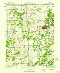 1942 Shelbyville1958 Print · USGSShelby County at the start of the 1940s reveals a landscape defined by the winding Kaskaskia River and its many bridge crossings. Researchers can trace family history through dozens of rural landmarks like Williamsburg Hill, Glenwood Cem, and Sandy Hill Sch.2 unique versions available
 - 1945 Map of St. Elmo
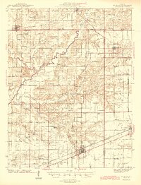 1945 St. Elmo1945 Print · USGSFayette and Effingham counties are seen here in the 1940s at a peak of rail and river industry. Genealogists and historians can trace family locations near Saint Elmo, locate the Carter Refinery, or find rural landmarks like Crums Chapel and Meyers Cem.2 unique versions available
 - 1946 Map of Shelbyville
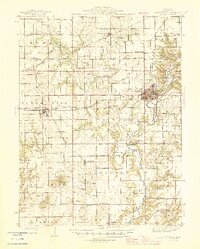 1946 Shelbyville1946 Print · USGSMid-century Shelby County centers on the rail-and-river hub of Shelbyville during an era of thriving rural townships. Genealogists can trace hundreds of family sites, from the County Poor Farm to Ragweed Sch and Gallagher Chapel Cem.2 unique versions available
 - 1958 Map of Decatur, 1971 Print
 1958 Decatur1971 Print · USGSCentral Illinois in the mid-twentieth century shows a landscape defined by industrial rail hubs and the creation of large reservoirs. Researchers can trace historic corridors like the Penn Central or locate landmarks such as Lincoln Log Cabin State Park and Lake Springfield.3 unique versions available
 - 1961 Map of Decatur
 1961 Decatur1961 Print · USGSCentral Illinois in the late fifties was a bustling corridor of rail lines and prairie commerce centered on the state capital. Genealogists and historians can trace the intricate connections between Springfield, Decatur, and dozens of smaller settlements like Nokomis and Arcola.2 unique versions available
 - 1981 Map of Fancher, 1982 Print
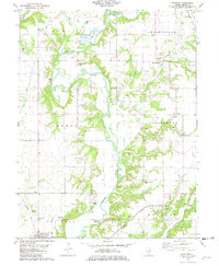 1981 Fancher1982 Print · USGSShelby County farmland and the winding Kaskaskia River valley are captured here in the early eighties. Local historians can trace rail-side settlements like Fancher and Clarksburg or locate historic sites like the Thompson Mill Covered Bridge and Gallagher Chapel Cem.
 - 1983 Map of Beecher City
 1983 Beecher City1983 Print · USGSBeecher City and the surrounding prairie were hubs of rail and resource extraction in the early 1980s. Genealogists can locate family burial sites like Tipsword Cem and Hubbard Cem, or trace the tracks of the Baltimore and Ohio through Moccasin.
 - 1986 Map of Effingham
 1986 Effingham1986 Print · USGSCentral Illinois during the mid-eighties was a hub of rail travel and water recreation centered on the new reservoirs. Genealogists and historians can trace the rural landscape between Mattoon and Effingham, locating landmarks like St Paul Ch and Eagle Creek State Park.2 unique versions available
 - 1998 Map of Fancher, 2003 Print
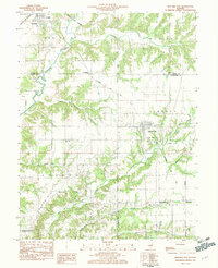
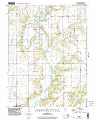 1998 Fancher2003 Print · USGSShelby County at the end of the twentieth century remains centered on the winding Kaskaskia River and its rural settlements. Genealogists can trace family landmarks like the Thompson Mill Covered Bridge, Gallagher Chapel Cem, and Fancher Cem.
End of results
Showing maps 1-10 of 10
Top cities near Cowden
- Pana historical maps
- Shelbyville historical maps
- Altamont historical maps
- St. Elmo historical maps
- Saint Elmo historical maps
- Stewardson historical maps
See more
Frequently asked questions
- What are the different types of historical maps available for Cowden?
- What is the oldest map of Cowden?
- Where can I purchase historical maps of Cowden for my home or office?
- Where can I download high-res historical maps of Cowden?
- Are there historical topographic maps available for Cowden?
- Is there historical aerial imagery available for Cowden?
- Where are historical maps of Cowden sourced from?