1970s Maps of Morton, Illinois
Explore 2 historic maps of Morton from the 1970s. These maps offer a rare glimpse into what life looked like during the 1970s — showing old roads, neighborhoods, homes, and landmarks that have changed or disappeared over time.
Whether you're researching your family's past, planning a metal detecting trip, or studying how Morton's landscape evolved across the 1970s, these high-resolution maps are a powerful tool for exploring the history of this region.
- Focus on a specific era: All maps on this page are from the 1970s, giving you a focused view of this time period.
- See what’s changed: Compare century-old streets, trails, and buildings to today's modern landscape using overlays and satellite layers.
- Research with precision: Use these maps for genealogy, historical research, land use analysis, or educational projects.
- View, download, or print: Maps are fully viewable online in high resolution, and can be downloaded or printed for your own records.
Start exploring Morton's history through authentic maps from the 1970s. This is your window into the past.
Morton, IL maps
(2)- 1970 Map of Washington, 1972 Print
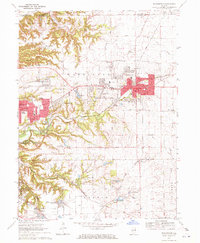 1970 Washington1972 Print · USGSTazewell County's expansion is clearly visible in the early seventies as the residential edges of WASHINGTON and MORTON begin to spread across the Illinois prairie. Researchers can trace family history through numerous rural burial sites like Guth Cem and Herstein Cem or locate local landmarks like the Smitty Landing Strip.2 unique versions available
 - 1970 Map of Morton, 1972 Print
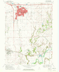 1970 Morton1972 Print · USGSTazewell County in the early seventies shows the expansion of Morton alongside its long-standing rail networks. Local historians can trace old community landmarks from Allentown to rural burial sites like Buckeye Cem and Walnut Cem.2 unique versions available
End of results
Showing maps 1-2 of 2
Top cities near Morton
- Peoria historical maps
- Pekin historical maps
- East Peoria historical maps
- Groveland historical maps
- Washington historical maps
- Bartonville historical maps
See more
Top neighborhoods of Morton
Frequently asked questions
- What are the different types of historical maps available for Morton?
- What is the oldest map of Morton?
- Where can I purchase historical maps of Morton for my home or office?
- Where can I download high-res historical maps of Morton?
- Are there historical topographic maps available for Morton?
- Is there historical aerial imagery available for Morton?
- Where are historical maps of Morton sourced from?