1990s Maps of Monmouth, Illinois
Explore 3 historic maps of Monmouth from the 1990s. These maps offer a rare glimpse into what life looked like during the 1990s — showing old roads, neighborhoods, homes, and landmarks that have changed or disappeared over time.
Whether you're researching your family's past, planning a metal detecting trip, or studying how Monmouth's landscape evolved across the 1990s, these high-resolution maps are a powerful tool for exploring the history of this region.
- Focus on a specific era: All maps on this page are from the 1990s, giving you a focused view of this time period.
- See what’s changed: Compare century-old streets, trails, and buildings to today's modern landscape using overlays and satellite layers.
- Research with precision: Use these maps for genealogy, historical research, land use analysis, or educational projects.
- View, download, or print: Maps are fully viewable online in high resolution, and can be downloaded or printed for your own records.
Start exploring Monmouth's history through authentic maps from the 1990s. This is your window into the past.
Monmouth, IL maps
(3)- 1990 Map of Burlington
 1990 Burlington1990 Print · USGSThe tri-state confluence of Iowa, Illinois, and Missouri is mapped here at the end of the twentieth century. Genealogists and historians can trace the riverfront heritage of Burlington, Keokuk, and Fort Madison, or locate sites like the Battle of Athens State Historic Site.2 unique versions available
 - 1996 Map of Cameron, 1997 Print
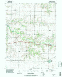 1996 Cameron1997 Print · USGSThe rural landscapes of Warren County appear here during the late twentieth century, showing the enduring grid of prairie townships. Genealogists can trace family heritage at Terpening Cem and Ogden Cem or locate the old Warren Sch near Monmouth.
 - 1998 Map of Monmouth, 2000 Print
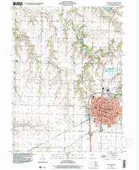 1998 Monmouth2000 Print · USGSWarren County at the close of the millennium centers on the thriving college town of Monmouth. Genealogists and local historians can trace the town's expansion toward Citizens Lake and locate rural landmarks like St Marys Cem or the Yorkwood High Sch.
End of results
Showing maps 1-3 of 3
Top cities near Monmouth
- Galesburg historical maps
- Abingdon historical maps
- Roseville historical maps
- Kirkwood historical maps
- Greenbush historical maps
- Coldbrook historical maps
See more
Frequently asked questions
- What are the different types of historical maps available for Monmouth?
- What is the oldest map of Monmouth?
- Where can I purchase historical maps of Monmouth for my home or office?
- Where can I download high-res historical maps of Monmouth?
- Are there historical topographic maps available for Monmouth?
- Is there historical aerial imagery available for Monmouth?
- Where are historical maps of Monmouth sourced from?