1990s Maps of Utah, Illinois
Explore 2 historic maps of Utah from the 1990s. These maps offer a rare glimpse into what life looked like during the 1990s — showing old roads, neighborhoods, homes, and landmarks that have changed or disappeared over time.
Whether you're researching your family's past, planning a metal detecting trip, or studying how Utah's landscape evolved across the 1990s, these high-resolution maps are a powerful tool for exploring the history of this region.
- Focus on a specific era: All maps on this page are from the 1990s, giving you a focused view of this time period.
- See what’s changed: Compare century-old streets, trails, and buildings to today's modern landscape using overlays and satellite layers.
- Research with precision: Use these maps for genealogy, historical research, land use analysis, or educational projects.
- View, download, or print: Maps are fully viewable online in high resolution, and can be downloaded or printed for your own records.
Start exploring Utah's history through authentic maps from the 1990s. This is your window into the past.
Utah, IL maps
(2)- 1990 Map of Burlington
 1990 Burlington1990 Print · USGSThe tri-state confluence of Iowa, Illinois, and Missouri is mapped here at the end of the twentieth century. Genealogists and historians can trace the riverfront heritage of Burlington, Keokuk, and Fort Madison, or locate sites like the Battle of Athens State Historic Site.2 unique versions available
 - 1996 Map of Galesburg West, 1997 Print
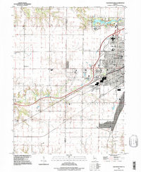 1996 Galesburg West1997 Print · USGSGalesburg was expanding westward in the 1990s as the urban grid reached into the surrounding Knox County farmland. Researchers can trace the layout of Knox College, find numerous family burial sites like Miles Cem, or locate the Galesburg Municipal Airport.
End of results
Showing maps 1-2 of 2
Top cities near Utah
- Galesburg historical maps
- Monmouth historical maps
- Abingdon historical maps
- Knoxville historical maps
- Ontario historical maps
- Viola historical maps
See more
Frequently asked questions
- What are the different types of historical maps available for Utah?
- What is the oldest map of Utah?
- Where can I purchase historical maps of Utah for my home or office?
- Where can I download high-res historical maps of Utah?
- Are there historical topographic maps available for Utah?
- Is there historical aerial imagery available for Utah?
- Where are historical maps of Utah sourced from?