1930s Maps of Crete, Illinois
Explore 2 historic maps of Crete from the 1930s. These maps offer a rare glimpse into what life looked like during the 1930s — showing old roads, neighborhoods, homes, and landmarks that have changed or disappeared over time.
Whether you're researching your family's past, planning a metal detecting trip, or studying how Crete's landscape evolved across the 1930s, these high-resolution maps are a powerful tool for exploring the history of this region.
- Focus on a specific era: All maps on this page are from the 1930s, giving you a focused view of this time period.
- See what’s changed: Compare century-old streets, trails, and buildings to today's modern landscape using overlays and satellite layers.
- Research with precision: Use these maps for genealogy, historical research, land use analysis, or educational projects.
- View, download, or print: Maps are fully viewable online in high resolution, and can be downloaded or printed for your own records.
Start exploring Crete's history through authentic maps from the 1930s. This is your window into the past.
Crete, IL maps
(2)- 1930 Map of Dyer
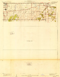 1930 Dyer1930 Print · USGSThe Illinois-Indiana borderlands appear in the late twenties during a period of industrial and automotive growth. Genealogists and local historians can trace early schoolhouse locations like Cats Corner School and the path of the famous Lincoln Highway near Dyer.
 - 1930 Map of Steger
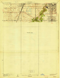 1930 Steger1930 Print · USGSThe southern outskirts of Chicago thrived as a rail and industrial nexus in the late twenties. Genealogists and historians can trace the early footprints of South Chicago Heights and Matteson, locating landmarks like St Annes Church and the Calvary Cemetery.2 unique versions available
End of results
Showing maps 1-2 of 2
Top cities near Crete
- Chicago historical maps
- Hammond historical maps
- Gary historical maps
- Orland Park historical maps
- Tinley Park historical maps
- Calumet City historical maps
See more
Top neighborhoods of Crete
Frequently asked questions
- What are the different types of historical maps available for Crete?
- What is the oldest map of Crete?
- Where can I purchase historical maps of Crete for my home or office?
- Where can I download high-res historical maps of Crete?
- Are there historical topographic maps available for Crete?
- Is there historical aerial imagery available for Crete?
- Where are historical maps of Crete sourced from?