1940s Maps of Kelleys, Illinois
Explore 2 historic maps of Kelleys from the 1940s. These maps offer a rare glimpse into what life looked like during the 1940s — showing old roads, neighborhoods, homes, and landmarks that have changed or disappeared over time.
Whether you're researching your family's past, planning a metal detecting trip, or studying how Kelleys's landscape evolved across the 1940s, these high-resolution maps are a powerful tool for exploring the history of this region.
- Focus on a specific era: All maps on this page are from the 1940s, giving you a focused view of this time period.
- See what’s changed: Compare century-old streets, trails, and buildings to today's modern landscape using overlays and satellite layers.
- Research with precision: Use these maps for genealogy, historical research, land use analysis, or educational projects.
- View, download, or print: Maps are fully viewable online in high resolution, and can be downloaded or printed for your own records.
Start exploring Kelleys's history through authentic maps from the 1940s. This is your window into the past.
Kelleys, IL maps
(2)- 1940 Map of Marion, 1958 Print
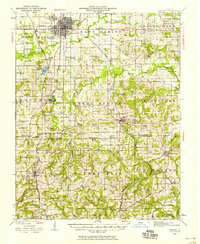 1940 Marion1958 Print · USGSSouthern Illinois during the early 1940s reveals a landscape defined by its rail junctions and scattered rural schools. Genealogists can trace family roots through sites like Bainbridge Cem, Pulleys Mill, and the many schools like Skaggs School.
 - 1949 Map of Paducah
 1949 Paducah1949 Print · USGSThe confluence of the Ohio, Mississippi, Tennessee, and Cumberland rivers at the close of the 1940s reveals a region bound by water and rail. Researchers can trace historic river landings, timberlands in the Shawnee National Forest, and the coal-mining infrastructure around West Frankfort and Herrin.2 unique versions available
End of results
Showing maps 1-2 of 2
Top cities near Kelleys
- Carbondale historical maps
- Marion historical maps
- Herrin historical maps
- Carterville historical maps
- Johnston City historical maps
- Cambria historical maps
See more
Frequently asked questions
- What are the different types of historical maps available for Kelleys?
- What is the oldest map of Kelleys?
- Where can I purchase historical maps of Kelleys for my home or office?
- Where can I download high-res historical maps of Kelleys?
- Are there historical topographic maps available for Kelleys?
- Is there historical aerial imagery available for Kelleys?
- Where are historical maps of Kelleys sourced from?