1960s Maps of Cass County, Indiana
Explore 10 historic maps of Cass County from the 1960s. These maps offer a rare glimpse into what life looked like during the 1960s — showing old roads, neighborhoods, homes, and landmarks that have changed or disappeared over time.
Whether you're researching your family's past, planning a metal detecting trip, or studying how Cass County's landscape evolved across the 1960s, these high-resolution maps are a powerful tool for exploring the history of this region.
- Focus on a specific era: All maps on this page are from the 1960s, giving you a focused view of this time period.
- See what’s changed: Compare century-old streets, trails, and buildings to today's modern landscape using overlays and satellite layers.
- Research with precision: Use these maps for genealogy, historical research, land use analysis, or educational projects.
- View, download, or print: Maps are fully viewable online in high resolution, and can be downloaded or printed for your own records.
Start exploring Cass County's history through authentic maps from the 1960s. This is your window into the past.
Cass County, IN maps
(10)- 1960 Map of Lucerne, 1963 Print
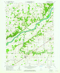
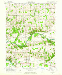
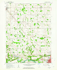 1960 Lucerne1963 Print · USGSCass County farmland meets the industrial north of Logansport in the early sixties, as the local rail and river economy transitioned for a new decade. Trace family history through landmarks like Royal Center Cem, Shiloh Ch, and the Old Indian Treaty Boundary.2 unique versions available
 - 1960 Map of Fulton, 1963 Print
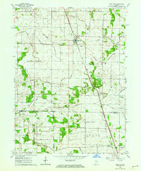
 1960 Fulton1963 Print · USGSFulton County agricultural life is centered on the town of Fulton during the mid-twentieth century. Genealogists and historians can trace an extensive network of family-named drainage projects like the Sylvester Maroney Ditch and local landmarks like Olive Branch Ch.2 unique versions available
 - 1960 Map of Macy, 1963 Print
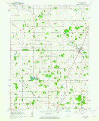
 1960 Macy1963 Print · USGSMiami and Fulton counties are captured here in the early 1960s, a period when the rural landscape was defined by its railroad crossings and small townships. Researchers can trace the junction of two major lines at Macy or locate ancestral sites like Mud Lake Chapel and Plainview Cemetery.3 unique versions available
 - 1960 Map of Grass Creek, 1964 Print
 1960 Grass Creek1964 Print · USGSIndiana farm country in the early sixties is defined here by the iron rails of the Pennsylvania and a complex web of drainage ditches. Genealogists can locate family-named sites like Bowman Cem, O'Brien Lake, and the rural West Union Ch.3 unique versions available
 - 1962 Map of Burrows, 1963 Print
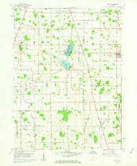
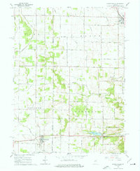
 1962 Burrows1963 Print · USGSThe Wabash River valley in the early sixties is shown here during a time of settled rail and river history. Genealogists and local researchers can locate numerous family landmarks and burial sites like Seceder Cem, IOOF Cem, and Township Sch.3 unique versions available
 - 1962 Map of Star City, 1964 Print
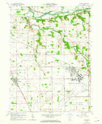
 1962 Star City1964 Print · USGSPulaski County agricultural life is captured here in the early 1960s, showing the intersection of rail transport and rural community centers. Researchers can trace the lineage of Star City and Thornhope, locating the I O O F Cem and the local Twp Sch.
 - 1962 Map of Burnettsville, 1964 Print
 1962 Burnettsville1964 Print · USGSIndiana’s agricultural heartland is captured here in the early sixties as the borderlands of White and Cass counties were firmly established. Local historians can trace the Pennsylvania rail line past Lake Cicott and find rural landmarks like Zion Cem, Davis Cem, and the Micro-Midget Racetrack.2 unique versions available
 - 1962 Map of Clymers, 1964 Print
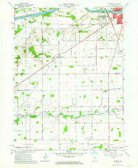 1962 Clymers1964 Print · USGSThe river and rail corridors of Cass County are documented here in the early 1960s as Logansport expands. Genealogists and local historians can trace family locations near St Johns Cem, the community of Clymers, and the Wabash and Erie Canal.3 unique versions available
 - 1963 Map of Twelve Mile, 1964 Print
 1963 Twelve Mile1964 Print · USGSCass County agriculture and river life converged in the early sixties as railroads like the Chesapeake and Ohio linked rural communities. Genealogists can trace family roots through Mt Carmel Ch, Bethlehem Ch, and the Eel River Chapel Cem.4 unique versions available
 - 1963 Map of Onward, 1964 Print
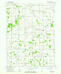
 1963 Onward1964 Print · USGSCass and Miami counties come into focus during the early sixties as military expansion meets rural tradition. Trace the footprint of the Bunker Hill Air Force Base and find local landmarks like Old Order Ch and the Bowyer Cem.3 unique versions available
End of results
Showing maps 1-10 of 10
Top cities of Cass County
- Logansport historical maps
- Galveston historical maps
- Royal Center historical maps
- Onward historical maps
Frequently asked questions
- What are the different types of historical maps available for Cass County?
- What is the oldest map of Cass County?
- Where can I purchase historical maps of Cass County for my home or office?
- Where can I download high-res historical maps of Cass County?
- Are there historical topographic maps available for Cass County?
- Is there historical aerial imagery available for Cass County?
- Where are historical maps of Cass County sourced from?