1950s Maps of Cass County, Indiana
Explore 9 historic maps of Cass County from the 1950s. These maps offer a rare glimpse into what life looked like during the 1950s — showing old roads, neighborhoods, homes, and landmarks that have changed or disappeared over time.
Whether you're researching your family's past, planning a metal detecting trip, or studying how Cass County's landscape evolved across the 1950s, these high-resolution maps are a powerful tool for exploring the history of this region.
- Focus on a specific era: All maps on this page are from the 1950s, giving you a focused view of this time period.
- See what’s changed: Compare century-old streets, trails, and buildings to today's modern landscape using overlays and satellite layers.
- Research with precision: Use these maps for genealogy, historical research, land use analysis, or educational projects.
- View, download, or print: Maps are fully viewable online in high resolution, and can be downloaded or printed for your own records.
Start exploring Cass County's history through authentic maps from the 1950s. This is your window into the past.
Cass County, IN maps
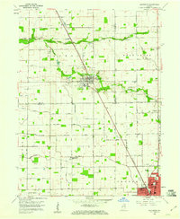
(9)- 1951 Map of Onward
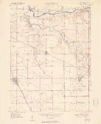 1951 Onward1951 Print · USGSMid-century Cass County is defined here by its intersection of rail and river commerce just as military land use began to shift. Genealogists can trace family names and local sites like Boyer Cem, McNelly Chapel, and the decommissioned Bunker Hill Naval Air Station.2 unique versions available
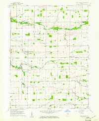
 - 1951 Map of Twelve Mile
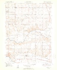 1951 Twelve Mile1951 Print · USGSCass and Miami County farmstead life and rail transit are captured here in the early fifties, as three major railroads crossed the landscape. Researchers can trace family roots through numerous rural landmarks like Old German Ch, Twelve Mile, and Eel River Chapel Cem.2 unique versions available
 - 1953 Map of Danville, 1965 Print
 1953 Danville1965 Print · USGSIndiana and Illinois crossroads come to life in this mid-century survey as the interstate era begins to reshape the river-and-rail landscape. Genealogists and collectors can trace the historic paths of the Nickel Plate railroad or locate smaller communities like Veedersburg, Goodland, and Bismarck.3 unique versions available
 - 1955 Map of Danville
 1955 Danville1955 Print · USGSThe Indiana-Illinois borderlands during the mid-fifties reveal a landscape of thriving rail hubs and university towns. Researchers can trace the legacy of Purdue University, the Tippecanoe Battlefield, and the path of the Pennsylvania RR.
 - 1955 Map of Logansport, 1957 Print
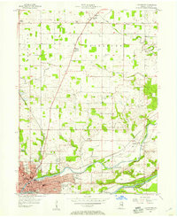 1955 Logansport1957 Print · USGSLogansport sits at the historic meeting of the Wabash and Eel Rivers during the mid-fifties, serving as a vital rail and transit hub. Genealogists can trace family roots at Mt Hope Cem, visit the St Francis of Assisi Novitiate, or follow the Old Michigan Road north to Metea.
 - 1955 Map of Anoka, 1957 Print
 1955 Anoka1957 Print · USGSThe convergence of the Wabash and Eel rivers at Logansport in the mid-1950s reveals a landscape of industrial hubs and rural townships. Genealogists can trace family roots through numerous sites like Walton Odd Fellows Cem, Blue Ball Ch, and the settlement at Anoka.
 - 1956 Map of Danville
 1956 Danville1956 Print · USGSMid-century Indiana and Illinois are captured here as the river-and-rail economy evolved into the modern highway era. Researchers can trace ancestral roots and old transport lines through Logansport, Battle Ground, and the dams at Lake Shafer.
 - 1959 Map of Galveston, 1960 Print
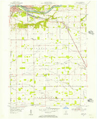
 1959 Galveston1960 Print · USGSGalveston and northern Howard County appear here in the late fifties, showcasing a landscape of railway-connected villages and tidy farm grids. Researchers can trace family history at Mt Zion Ch or locate old burial grounds like Sprinkle Cem and Rush Cem.3 unique versions available
 - 1959 Map of Young America, 1961 Print
 1959 Young America1961 Print · USGSThe rural crossroads and fertile farmsteads of Howard and Cass Counties are captured here in the late 1950s. Local historians can trace family locations near Young America and Kappa Corner or locate vanished landmarks like the Galveston Airport and Ervin Sch.2 unique versions available
End of results
Showing maps 1-9 of 9
Top cities of Cass County
- Logansport historical maps
- Galveston historical maps
- Royal Center historical maps
- Onward historical maps
Frequently asked questions
- What are the different types of historical maps available for Cass County?
- What is the oldest map of Cass County?
- Where can I purchase historical maps of Cass County for my home or office?
- Where can I download high-res historical maps of Cass County?
- Are there historical topographic maps available for Cass County?
- Is there historical aerial imagery available for Cass County?
- Where are historical maps of Cass County sourced from?