
1951 Map of Onward
USGS Topo · Published 1951About this map
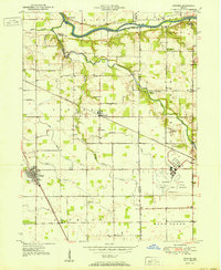
The Wabash River carves the northern edge of this North Central Indiana landscape, where the Pennsylvania railroad cuts a straight diagonal through the heart of the terrain. The map captures a post-war rural environment defined by the transition of land use, most notably indicated by the Bunker Hill Naval Air Station, which is marked as decommissioned. This military footprint stands in contrast to the surrounding agricultural grid, which is dotted with long-established community anchors such as McNelly Chapel, Old Order Ch, and Pipe Creek Church.
Find a feature on this map
29 named features on this map. Tap any name to fly to it.
Don’t see what you’re looking for? This feature index may not catch every label — zoom into the map to look around manually.
Map Details
Editions of this 1951 Onward Map
2 editions found
Other maps of this area

1951 · Peru
USGS Topo · 1:24,000

1951 · Twelve Mile
USGS Topo · 1:24,000

1951 · Bunker Hill
USGS Topo · 1:24,000

1953 · Danville
USGS Topo · 1:250,000

1955 · Danville
USGS Topo · 1:250,000

1955 · Logansport
USGS Topo · 1:24,000

1955 · Anoka
USGS Topo · 1:24,000

1956 · Danville
USGS Topo · 1:250,000

1959 · Galveston
USGS Topo · 1:24,000

1959 · Miami
USGS Topo · 1:24,000