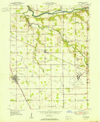
1951 Map of Onward
USGS Topo · Published 1951About this map
Bunker Hill Naval Air Station stands as a prominent feature in the southeast corner of this mid-century landscape, marked as decommissioned at the time of the 1949 topography survey. The area is defined by its agricultural character and the transition from the high ground near Bunker Hill down to the Wabash River valley in the north. The Pennsylvania railroad line cuts diagonally across the terrain, serving the small agricultural hubs of Walton and Onward. Local history is deeply embedded in the rural landscape through a network of country churches and cemeteries, such as Pipe Creek Church, McNelly Chapel, and the Metzger Cem. Waterways like Pipe Creek and Deer Creek wind through the township boundaries, illustrating the natural drainage patterns that shaped early settlement and farm placement in this section of Cass and Miami counties.
Find a feature on this map
31 named features on this map. Tap any name to fly to it.
Don’t see what you’re looking for? This feature index may not catch every label — zoom into the map to look around manually.
Map Details
Editions of this 1951 Onward Map
2 editions found
Other maps of this area

1951 · Peru
USGS Topo · 1:24,000

1951 · Onward
USGS Topo · 1:24,000

1951 · Twelve Mile
USGS Topo · 1:24,000

1951 · Bunker Hill
USGS Topo · 1:24,000

1953 · Danville
USGS Topo · 1:250,000

1955 · Danville
USGS Topo · 1:250,000

1955 · Logansport
USGS Topo · 1:24,000

1955 · Anoka
USGS Topo · 1:24,000

1956 · Danville
USGS Topo · 1:250,000

1959 · Galveston
USGS Topo · 1:24,000