1900-1909 Maps of Roadman Corner, Indiana
Explore 1 historic maps of Roadman Corner from 1900-1909. These maps offer a rare glimpse into what life looked like during the 1900s — showing old roads, neighborhoods, homes, and landmarks that have changed or disappeared over time.
Whether you're researching your family's past, planning a metal detecting trip, or studying how Roadman Corner's landscape evolved across the 1900s, these high-resolution maps are a powerful tool for exploring the history of this region.
- Focus on a specific era: All maps on this page are from the 1900s, giving you a focused view of this time period.
- See what’s changed: Compare century-old streets, trails, and buildings to today's modern landscape using overlays and satellite layers.
- Research with precision: Use these maps for genealogy, historical research, land use analysis, or educational projects.
- View, download, or print: Maps are fully viewable online in high resolution, and can be downloaded or printed for your own records.
Start exploring Roadman Corner's history through authentic maps from the 1900s. This is your window into the past.
Roadman Corner, IN maps
(1)- 1908 Map of Clay City
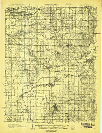 1908 Clay City1908 Print · USGSIndiana's coal and timber country comes alive in the years before the Great War, showing a landscape defined by deep river valleys and early rail lines. Genealogists can trace hundreds of family sites near Clay City and Center Point, or locate historic gathering places like Wesley Chapel and Roadman School.
End of results
Showing maps 1-1 of 1
Top cities near Roadman Corner
- Greencastle historical maps
- Brazil historical maps
- Cloverdale historical maps
- Seelyville historical maps
- Clay City historical maps
- Knightsville historical maps
See more
Frequently asked questions
- What are the different types of historical maps available for Roadman Corner?
- What is the oldest map of Roadman Corner?
- Where can I purchase historical maps of Roadman Corner for my home or office?
- Where can I download high-res historical maps of Roadman Corner?
- Are there historical topographic maps available for Roadman Corner?
- Is there historical aerial imagery available for Roadman Corner?
- Where are historical maps of Roadman Corner sourced from?