Old Maps of Switzer Crossroads, Indiana for Hiking & Exploration
Hike through history with 13 historic maps of Switzer Crossroads. Explore old trails, ghost towns, and forgotten backroads — perfect for outdoor adventurers and local explorers.
- Rediscover forgotten places: Map out old mining camps, roads, and footpaths that no longer exist on modern maps.
- Layer with modern tools: Combine with LiDAR or satellite views to plan hikes through historical terrain.
- Made for exploration: Popular among hikers, overlanders, and local history lovers.
Use these maps to find adventure and explore the hidden past of Switzer Crossroads.
Switzer Crossroads, IN maps
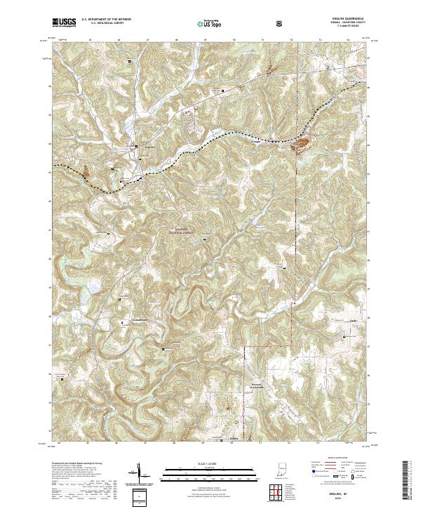
(13)- 1950 Map of English, 1953 Print
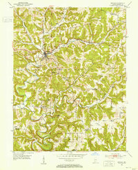 1950 English1953 Print · USGSCrawford County at mid-century reveals a landscape of deep timber and river valleys where the Southern railroad meets the winding Little Blue River. Genealogists can trace rural family life through scattered landmarks like Simpson Chapel, Dog Creek Sch, and the Sloan Cem.
 - 1956 Map of Vincennes, 1967 Print
 1956 Vincennes1967 Print · USGSSouthern Indiana and the Illinois borderlands are captured here in the mid-fifties, showing the region's dense network of river towns and rail lines. Researchers can trace historic river crossings along the Wabash River or locate landmarks like Wyandotte Cave and Lincoln State Park.4 unique versions available
 - 1957 Map of Vincennes
 1957 Vincennes1957 Print · USGSSouthwest Indiana and the Illinois borderlands come alive in the late 1950s, a period of heavy rail traffic and expanding state forests. Genealogists and historians can trace the riverfronts and rail lines of Vincennes, New Harmony, and the vast Crane Naval Ammunition Depot.
 - 1958 Map of Vincennes
 1958 Vincennes1958 Print · USGSSouthern Indiana and the Illinois borderlands are captured during a mid-century period of heavy rail traffic and military activity. Researchers can trace the sprawling bounds of the Crane Naval Ammunition Depot or locate historic settlements like New Harmony and French Lick.2 unique versions available
 - 1966 Map of English, 1968 Print
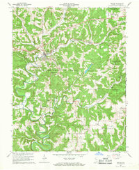 1966 English1968 Print · USGSCrawford County at the midpoint of the sixties is shown here as a landscape of forest preserves and small rail-side communities. Genealogists can trace family roots at Dillman Ch, Hamilton Cem, and rural crossroads like Grantsburg and Switzer Crossroads.3 unique versions available
 - 1986 Map of Jasper
 1986 Jasper1986 Print · USGSSouthern Indiana in the 1980s is defined by the expansive Patoka Lake and the dense timber of the Hoosier National Forest. Researchers can trace the Southern RR through the hills or locate historic sites like Saint Meinrad and Sulphur Springs.
 - 1993 Map of English, 1996 Print
 1993 English1996 Print · USGSCrawford County, Indiana, is shown here in the 1990s as the SOUTHERN railroad snakes through a landscape defined by the HOOSIER NATIONAL FOREST. Local historians can trace established rural communities like Grantsburg and Curby, along with the Stewart Cem and the waters of the English Reservoir.
 - 1994 Map of Jasper
 1994 Jasper1994 Print · USGSSouthern Indiana and the Kentucky borderlands are captured here in the mid-nineties, showing a landscape defined by the Ohio River and dense state forests. Genealogists can locate family landmarks like Saint Meinrad Archabbey, Saint Anthony, and the historic Lincoln Boyhood National Memorial.
 - 2010 Map of English, 2010 Print
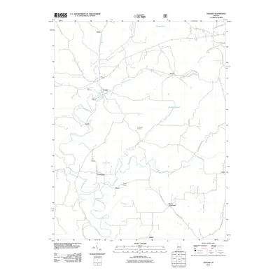 2010 English2010 Print · USGSCovers Switzer Crossroads, including English, Grantsburg, and other nearby areas
 - 2013 Map of English, 2013 Print
 2013 English2013 Print · USGSCovers Switzer Crossroads, including English, Grantsburg, and other nearby areas
 - 2016 Map of English, 2016 Print
 2016 English2016 Print · USGSCovers Switzer Crossroads, including English, Grantsburg, and other nearby areas
 - 2019 Map of English, 2019 Print
 2019 English2019 Print · USGSCovers Switzer Crossroads, including English, Grantsburg, and other nearby areas
 - 2022 Map of English, 2022 Print
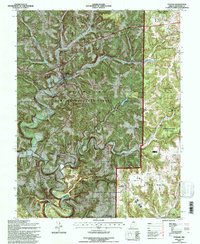
 2022 English2022 Print · USGSCrawford County's wooded hills and small valley settlements are captured here in the early twenty-first century. Genealogists and local historians can locate many family landmarks, from the Crawford County Courthouse in English to the Dillman Cem and Grantsburg Cem.
End of results
Showing maps 1-13 of 13
Top cities near Switzer Crossroads
- Marengo historical maps
- Leopold historical maps
- English historical maps
- Leavenworth historical maps
- Hardinsburg historical maps
- Fredericksburg historical maps
See more
Frequently asked questions
- What are the different types of historical maps available for Switzer Crossroads?
- What is the oldest map of Switzer Crossroads?
- Where can I purchase historical maps of Switzer Crossroads for my home or office?
- Where can I download high-res historical maps of Switzer Crossroads?
- Are there historical topographic maps available for Switzer Crossroads?
- Is there historical aerial imagery available for Switzer Crossroads?
- Where are historical maps of Switzer Crossroads sourced from?