1970s Maps of Cannelburg, Indiana
Explore 2 historic maps of Cannelburg from the 1970s. These maps offer a rare glimpse into what life looked like during the 1970s — showing old roads, neighborhoods, homes, and landmarks that have changed or disappeared over time.
Whether you're researching your family's past, planning a metal detecting trip, or studying how Cannelburg's landscape evolved across the 1970s, these high-resolution maps are a powerful tool for exploring the history of this region.
- Focus on a specific era: All maps on this page are from the 1970s, giving you a focused view of this time period.
- See what’s changed: Compare century-old streets, trails, and buildings to today's modern landscape using overlays and satellite layers.
- Research with precision: Use these maps for genealogy, historical research, land use analysis, or educational projects.
- View, download, or print: Maps are fully viewable online in high resolution, and can be downloaded or printed for your own records.
Start exploring Cannelburg's history through authentic maps from the 1970s. This is your window into the past.
Cannelburg, IN maps
(2)- 1974 Map of Loogootee, 1976 Print
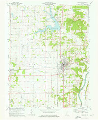 1974 Loogootee1976 Print · USGSLoogootee and the surrounding Indiana countryside are captured here in the mid-seventies as recreation and industry balanced against traditional farming life. Genealogists can locate family sites at St Johns Cemetery or Houghton Cem while tracing the Baltimore and Ohio rail line.2 unique versions available
 - 1979 Map of Montgomery
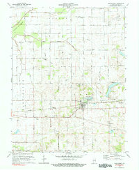 1979 Montgomery1979 Print · USGSDaviess County farmland and small-town life are captured in the late seventies along the busy Baltimore and Ohio railroad. Genealogists can trace local roots through rural landmarks like St Peters Cem, Berea Ch, and the Pleasant View Sch.
End of results
Showing maps 1-2 of 2
Top cities near Cannelburg
- Washington historical maps
- Loogootee historical maps
- Odon historical maps
- Shoals historical maps
- Elnora historical maps
- Plainville historical maps
See more
Frequently asked questions
- What are the different types of historical maps available for Cannelburg?
- What is the oldest map of Cannelburg?
- Where can I purchase historical maps of Cannelburg for my home or office?
- Where can I download high-res historical maps of Cannelburg?
- Are there historical topographic maps available for Cannelburg?
- Is there historical aerial imagery available for Cannelburg?
- Where are historical maps of Cannelburg sourced from?