1980s Maps of Dearborn County, Indiana
Explore 7 historic maps of Dearborn County from the 1980s. These maps offer a rare glimpse into what life looked like during the 1980s — showing old roads, neighborhoods, homes, and landmarks that have changed or disappeared over time.
Whether you're researching your family's past, planning a metal detecting trip, or studying how Dearborn County's landscape evolved across the 1980s, these high-resolution maps are a powerful tool for exploring the history of this region.
- Focus on a specific era: All maps on this page are from the 1980s, giving you a focused view of this time period.
- See what’s changed: Compare century-old streets, trails, and buildings to today's modern landscape using overlays and satellite layers.
- Research with precision: Use these maps for genealogy, historical research, land use analysis, or educational projects.
- View, download, or print: Maps are fully viewable online in high resolution, and can be downloaded or printed for your own records.
Start exploring Dearborn County's history through authentic maps from the 1980s. This is your window into the past.
Dearborn County, IN maps
(7)- 1981 Map of Hooven, 1982 Print
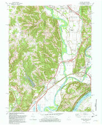 1981 Hooven1982 Print · USGSThe Ohio-Indiana-Kentucky borderlands are captured here in the early eighties as industrial gravel operations and rail lines shaped the river valleys. Researchers can trace the Conrail lines through Valley Junction or locate old burial sites like Sugar Ridge Cem and Maple Grove Cem.2 unique versions available
 - 1981 Map of Aurora, 1982 Print
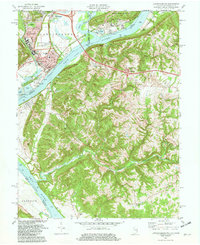
 1981 Aurora1982 Print · USGSThe Indiana-Kentucky borderlands come alive in this early 1980s survey of the riverfront corridor between Aurora and Lawrenceburg. Researchers can trace the path of the Baltimore and Ohio Railroad and locate rural landmarks like Mt Tabor Ch and Kirschs Corner.2 unique versions available
 - 1981 Map of Lawrenceburg, 1982 Print
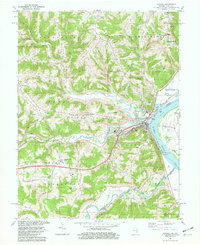
 1981 Lawrenceburg1982 Print · USGSThe tri-state junction of Indiana, Kentucky, and Ohio is captured here in the early eighties as the river economy matured. Researchers can trace family history through numerous burial sites like Greendale Cem and Petersburg Cem or locate the old Courthouse in Lawrenceburg.3 unique versions available
 - 1986 Map of Cincinnati
 1986 Cincinnati1986 Print · USGSGreater Cincinnati and its tri-state surrounds are captured here in the mid-eighties as suburban growth reached into the neighboring hills and river valleys. Researchers can trace the development of transit hubs like Greater Cincinnati International Airport and historic sites such as Spring Grove Cemetery.3 unique versions available
 - 1986 Map of Greensburg
 1986 Greensburg1986 Print · USGSSoutheastern Indiana in the mid-eighties shows a balance of growing industrial centers and deeply rooted rural communities. Family historians can trace landmarks like the Highland Center School, South Park Cemetery, and the Bartholomew County Courthouse among the river forks.2 unique versions available
 - 1986 Map of Madison
 1986 Madison1986 Print · USGSSouthern Indiana and Northern Kentucky are shown here in the mid-eighties, centered on the river corridor and the sprawling Jefferson Proving Ground. Genealogists and historians can trace rail lines like the Seaboard System and locate river towns from Madison to Bethlehem.
 - 1986 Map of Falmouth
 1986 Falmouth1986 Print · USGSNorthern Kentucky and the Ohio River valley are shown here in the mid-1980s, highlighting the region's complex river-and-rail geography. Genealogists and researchers can trace the roads connecting Big Bone Lick, Zion Church, and river towns like Falmouth and Augusta.2 unique versions available
End of results
Showing maps 1-7 of 7
Frequently asked questions
- What are the different types of historical maps available for Dearborn County?
- What is the oldest map of Dearborn County?
- Where can I purchase historical maps of Dearborn County for my home or office?
- Where can I download high-res historical maps of Dearborn County?
- Are there historical topographic maps available for Dearborn County?
- Is there historical aerial imagery available for Dearborn County?
- Where are historical maps of Dearborn County sourced from?