1960s Maps of Dearborn County, Indiana
Explore 4 historic maps of Dearborn County from the 1960s. These maps offer a rare glimpse into what life looked like during the 1960s — showing old roads, neighborhoods, homes, and landmarks that have changed or disappeared over time.
Whether you're researching your family's past, planning a metal detecting trip, or studying how Dearborn County's landscape evolved across the 1960s, these high-resolution maps are a powerful tool for exploring the history of this region.
- Focus on a specific era: All maps on this page are from the 1960s, giving you a focused view of this time period.
- See what’s changed: Compare century-old streets, trails, and buildings to today's modern landscape using overlays and satellite layers.
- Research with precision: Use these maps for genealogy, historical research, land use analysis, or educational projects.
- View, download, or print: Maps are fully viewable online in high resolution, and can be downloaded or printed for your own records.
Start exploring Dearborn County's history through authentic maps from the 1960s. This is your window into the past.
Dearborn County, IN maps
(4)- 1964 Map of Louisville
 1964 Louisville1964 Print · USGSThe Ohio River valley and Kentucky Bluegrass are captured in the mid-1960s, showing a region balanced between industrial growth and its agrarian roots. Genealogists and historians can trace the development of county seats like Shelbyville and Paris, or locate established institutions such as Georgetown College and Bernheim Forest.
 - 1965 Map of Aberdeen, 1967 Print
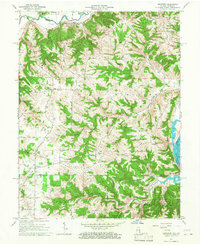 1965 Aberdeen1967 Print · USGSThe hills of Ohio and Switzerland counties are captured here in the mid-1960s, showing a landscape of high ridges and narrow creek bottoms. Genealogists can trace family landmarks and local centers like Aberdeen, Salem Ch, and the Grant Brothers Cem.3 unique versions available
 - 1966 Map of Aurora, 1967 Print
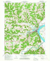 1966 Aurora1967 Print · USGSThe Ohio River valley and the busy Baltimore and Ohio rail line dominate the Dearborn County landscape during the mid-sixties. Genealogists and local historians can locate the old community of Wilmington, the industrial docks at Aurora, and historic sites like Mt Sinai Ch.
 - 1966 Map of Guilford, 1968 Print
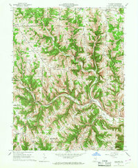 1966 Guilford1968 Print · USGSSoutheast Indiana during the mid-sixties reveals a landscape of high ridges and deep creek valleys anchored by historic rural parishes. Genealogists and local historians can trace family roots through the Huber Boggs Cem or locate old school sites like Manchester Sch and North Dearborn High Sch.2 unique versions available
End of results
Showing maps 1-4 of 4
Frequently asked questions
- What are the different types of historical maps available for Dearborn County?
- What is the oldest map of Dearborn County?
- Where can I purchase historical maps of Dearborn County for my home or office?
- Where can I download high-res historical maps of Dearborn County?
- Are there historical topographic maps available for Dearborn County?
- Is there historical aerial imagery available for Dearborn County?
- Where are historical maps of Dearborn County sourced from?