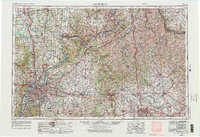
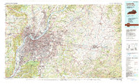
1964 Map of Louisville
USGS Topo · Published 1964About this map
The Ohio River serves as the central artery for this mid-century view of the Bluegrass region, marking the boundary between the expanding urban centers of Louisville and Southern Indiana's Jeffersonville and New Albany. To the east, the state capital of Frankfort and the horse country of Lexington anchor the landscape, connected by a maturing network of interstate highways and historic rail lines like the Louisville and Nashville RR. The map illustrates a period of significant regional infrastructure, including the Kentucky Turnpike and the massive footprints of Fort Knox and the Jefferson Proving Ground.
Find a feature on this map
132 named features on this map. Tap any name to fly to it.
Don’t see what you’re looking for? This feature index may not catch every label — zoom into the map to look around manually.
Map Details
Editions of this 1964 Louisville Map
This is the sole edition of this map. No revisions or reprints were ever made.
Historical Maps of Louisville Through Time
5 maps found