
Loading...
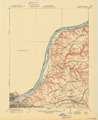
Loading map...1905 Map of Prospect
USGS Topo · Published 1962About this map
Louisville and Jeffersonville anchor the southwestern corner of this survey, which traces the Ohio River as it winds past early landings like Woolfolk Ldg and Harmony Ldg. The landscape is a network of turnpikes and electric rail lines, reflecting the early 20th-century expansion of the city into surrounding rural communities. Significant institutional landmarks include the Lakeland Asylum and the Kentucky Military Institute, which occupy prominent positions along the rail corridor.
Find a feature on this map
59 named features on this map. Tap any name to fly to it.
Don’t see what you’re looking for? This feature index may not catch every label — zoom into the map to look around manually.
Map Details
Date Portrayed1905
Date Published1962
PublisherU.S. Geological Survey
Map TypeTopographic
Scale1:62,500
Physical Dimensions17.1 x 21.1 inches
Editions of this 1905 Prospect Map
This is the sole edition of this map. No revisions or reprints were ever made.
Historical Maps of Louisville Through Time
Featured Locations
Source Details
SourceU.S. Geological Survey
CopyrightPublic Domain