1970s Maps of Fayette County, Indiana
Explore 5 historic maps of Fayette County from the 1970s. These maps offer a rare glimpse into what life looked like during the 1970s — showing old roads, neighborhoods, homes, and landmarks that have changed or disappeared over time.
Whether you're researching your family's past, planning a metal detecting trip, or studying how Fayette County's landscape evolved across the 1970s, these high-resolution maps are a powerful tool for exploring the history of this region.
- Focus on a specific era: All maps on this page are from the 1970s, giving you a focused view of this time period.
- See what’s changed: Compare century-old streets, trails, and buildings to today's modern landscape using overlays and satellite layers.
- Research with precision: Use these maps for genealogy, historical research, land use analysis, or educational projects.
- View, download, or print: Maps are fully viewable online in high resolution, and can be downloaded or printed for your own records.
Start exploring Fayette County's history through authentic maps from the 1970s. This is your window into the past.
Fayette County, IN maps
(5)- 1970 Map of Lewisville, 1973 Print
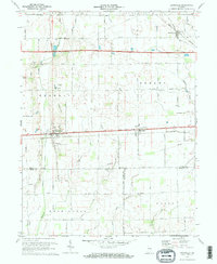 1970 Lewisville1973 Print · USGSEastern Indiana farmland transitions from the steam era to the late twentieth century in this detailed survey of Henry County. Researchers can trace historic family landmarks such as Ebenezer Cem, Rich Square Ch, and the corridor of the Penn Central railroad.2 unique versions available
 - 1971 Map of Alpine, 1973 Print
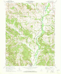 1971 Alpine1973 Print · USGSFayette and Franklin Counties come together along the river valley in the early seventies, where rail and water dominate the landscape. Researchers can trace the Penn Central tracks through Nulltown, Alpine, and Laurel, or locate family sites at Tullis Chapel Cem.3 unique versions available
 - 1972 Map of Everton, 1973 Print
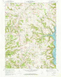 1972 Everton1973 Print · USGSThe rural borderlands of Fayette, Franklin, and Union counties are detailed here during the early seventies. Genealogists can locate family-named landmarks like Mt Garrison Cem and the Little Children Home, or trace the path of Village Creek.4 unique versions available
 - 1972 Map of Brownsville, 1973 Print
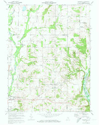 1972 Brownsville1973 Print · USGSFayette and Union Counties are captured here in the early seventies during the formation of the lake. Local historians can trace the foundations of communities like Springersville, find family plots at Philomath Cem, and locate the Covered Bridge at Brownsville.3 unique versions available
 - 1972 Map of Connersville, 1973 Print
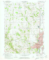 1972 Connersville1973 Print · USGSThe rail-and-river hub of Fayette County is captured here in the early seventies, showing a landscape shaped by the Whitewater River and the Penn Central tracks. Local historians can trace family roots through several rural burial grounds like Wiley Chapel Cem and 24 City Cemetery.2 unique versions available
End of results
Showing maps 1-5 of 5
Top cities of Fayette County
Frequently asked questions
- What are the different types of historical maps available for Fayette County?
- What is the oldest map of Fayette County?
- Where can I purchase historical maps of Fayette County for my home or office?
- Where can I download high-res historical maps of Fayette County?
- Are there historical topographic maps available for Fayette County?
- Is there historical aerial imagery available for Fayette County?
- Where are historical maps of Fayette County sourced from?