1950s Maps of Silver Hills, New Albany
Explore 4 historic maps of Silver Hills from the 1950s. These maps offer a rare glimpse into what life looked like during the 1950s — showing old roads, neighborhoods, homes, and landmarks that have changed or disappeared over time.
Whether you're researching your family's past, planning a metal detecting trip, or studying how Silver Hills's landscape evolved across the 1950s, these high-resolution maps are a powerful tool for exploring the history of this region.
- Focus on a specific era: All maps on this page are from the 1950s, giving you a focused view of this time period.
- See what’s changed: Compare century-old streets, trails, and buildings to today's modern landscape using overlays and satellite layers.
- Research with precision: Use these maps for genealogy, historical research, land use analysis, or educational projects.
- View, download, or print: Maps are fully viewable online in high resolution, and can be downloaded or printed for your own records.
Start exploring Silver Hills's history through authentic maps from the 1950s. This is your window into the past.
Silver Hills, New Albany maps
(4)- 1950 Map of New Albany, 1955 Print
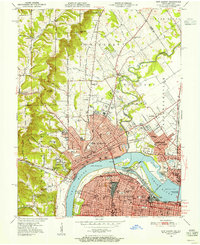 1950 New Albany1955 Print · USGSThe riverfront communities of Indiana and Kentucky meet at the Ohio River during a mid-century period of heavy industry and rail expansion. Genealogists and local historians can locate early burial grounds like Portland Cem, institutional landmarks such as the County Infirmary, and long-standing schools including McCulloch Sch.
 - 1951 Map of New Albany
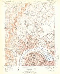 1951 New Albany1951 Print · USGSThe Ohio River waterfront at mid-century shows the industrial heart of New Albany and Louisville linked by massive river and rail works. Genealogists can trace family roots through neighborhood landmarks like Blackiston Mill, Portland Cem, and the Silvercrest State Hospital.2 unique versions available
 - 1955 Map of New Albany, 1956 Print
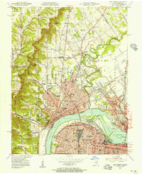 1955 New Albany1956 Print · USGSThe Ohio River separates the growing industrial hubs of New Albany and Louisville in the mid-fifties. Researchers can trace the extensive rail networks and local institutions of the day, from the Falls of the Ohio to the Silvercrest State Hospital.
 - 1956 Map of Louisville, 1971 Print
 1956 Louisville1971 Print · USGSThe Ohio River valley and the Kentucky Bluegrass are captured here during a period of rapid mid-century growth and industrial activity. Genealogists and historians can trace rail-centered towns and military land use at Fort Knox and the Jefferson Proving Ground.2 unique versions available
End of results
Showing maps 1-4 of 4
Top cities near Silver Hills
- Louisville historical maps
- Jeffersonville historical maps
- New Albany historical maps
- Clarksville historical maps
- Shively historical maps
- Mount Washington historical maps
See more
Frequently asked questions
- What are the different types of historical maps available for Silver Hills?
- What is the oldest map of Silver Hills?
- Where can I purchase historical maps of Silver Hills for my home or office?
- Where can I download high-res historical maps of Silver Hills?
- Are there historical topographic maps available for Silver Hills?
- Is there historical aerial imagery available for Silver Hills?
- Where are historical maps of Silver Hills sourced from?