1970s Maps of Whitcomb, Indiana
Explore 1 historic maps of Whitcomb from the 1970s. These maps offer a rare glimpse into what life looked like during the 1970s — showing old roads, neighborhoods, homes, and landmarks that have changed or disappeared over time.
Whether you're researching your family's past, planning a metal detecting trip, or studying how Whitcomb's landscape evolved across the 1970s, these high-resolution maps are a powerful tool for exploring the history of this region.
- Focus on a specific era: All maps on this page are from the 1970s, giving you a focused view of this time period.
- See what’s changed: Compare century-old streets, trails, and buildings to today's modern landscape using overlays and satellite layers.
- Research with precision: Use these maps for genealogy, historical research, land use analysis, or educational projects.
- View, download, or print: Maps are fully viewable online in high resolution, and can be downloaded or printed for your own records.
Start exploring Whitcomb's history through authentic maps from the 1970s. This is your window into the past.
Whitcomb, IN maps
(1)- 1974 Map of Whitcomb, 1975 Print
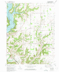 1974 Whitcomb1975 Print · USGSFranklin County's landscape shows the transformation from a river valley to a reservoir environment in the mid-1970s. Trace local roots at Big Cedar Ch, explore the community of Mount Carmel, or locate the historic earthworks of The Mounds.3 unique versions available
End of results
Showing maps 1-1 of 1
Top cities near Whitcomb
- Oxford historical maps
- Connersville historical maps
- Harrison historical maps
- Reily Township historical maps
- Logan historical maps
- Brookville historical maps
See more
Frequently asked questions
- What are the different types of historical maps available for Whitcomb?
- What is the oldest map of Whitcomb?
- Where can I purchase historical maps of Whitcomb for my home or office?
- Where can I download high-res historical maps of Whitcomb?
- Are there historical topographic maps available for Whitcomb?
- Is there historical aerial imagery available for Whitcomb?
- Where are historical maps of Whitcomb sourced from?