1960s Maps of Hamilton County, Indiana
Explore 14 historic maps of Hamilton County from the 1960s. These maps offer a rare glimpse into what life looked like during the 1960s — showing old roads, neighborhoods, homes, and landmarks that have changed or disappeared over time.
Whether you're researching your family's past, planning a metal detecting trip, or studying how Hamilton County's landscape evolved across the 1960s, these high-resolution maps are a powerful tool for exploring the history of this region.
- Focus on a specific era: All maps on this page are from the 1960s, giving you a focused view of this time period.
- See what’s changed: Compare century-old streets, trails, and buildings to today's modern landscape using overlays and satellite layers.
- Research with precision: Use these maps for genealogy, historical research, land use analysis, or educational projects.
- View, download, or print: Maps are fully viewable online in high resolution, and can be downloaded or printed for your own records.
Start exploring Hamilton County's history through authentic maps from the 1960s. This is your window into the past.
Hamilton County, IN maps
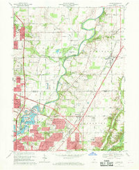
(14)- 1960 Map of Noblesville, 1961 Print
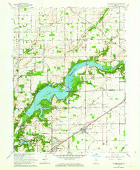
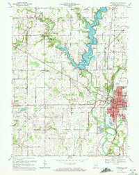
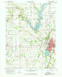 1960 Noblesville1961 Print · USGSNoblesville and the White River valley are captured in the early sixties as new landmarks like Morse Reservoir began to reshape the landscape. Local historians can trace old community centers such as Deming or locate family plots at Riverside Cem and Crownland Cem.2 unique versions available
 - 1961 Map of Sheridan, 1962 Print
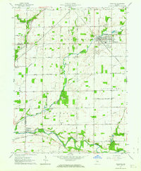
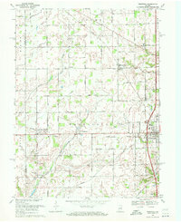
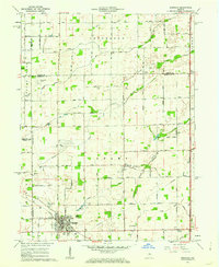 1961 Sheridan1962 Print · USGSSheridan and the surrounding Indiana farm country are captured here at the start of the 1960s, showing a landscape defined by rail and early aviation. Researchers can trace the MONON line through town or locate family sites at Crown Hill Cem, Wiles Cem, and Hills Ch.3 unique versions available
 - 1961 Map of Omega, 1962 Print
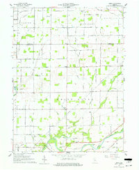 1961 Omega1962 Print · USGSNorth of Noblesville in the early sixties, this rural landscape reveals the agricultural heart of Hamilton and Tipton counties. Researchers can trace family roots through sites like Harveys Chapel, Buscher Cem, and the small settlements of Omega and Aroma.3 unique versions available
 - 1961 Map of Arcadia, 1963 Print
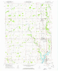 1961 Arcadia1963 Print · USGSNorth of the newly developed Morse Reservoir, the early 1960s landscape of Hamilton County centers on the busy rail towns of Arcadia and Atlanta. Genealogists and historians can trace family roots through several local landmarks like Taylor Cemetery, Roberts Chapel, and the Indiana Academy.4 unique versions available
 - 1962 Map of Indianapolis
 1962 Indianapolis1962 Print · USGSCentral Indiana and the Illinois borderlands are captured here in the early sixties, showing the region's dense rail networks and growing urban centers. Genealogists and historians can locate family-named landmarks and institutions like Crown Hill Cem, Indiana University, and the Indianapolis Motor Speedway.
 - 1962 Map of Mc Cordsville, 1963 Print
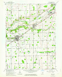
 1962 Mc Cordsville1963 Print · USGSThe Geist Reservoir area undergoes a mid-century transformation where rural crossroads meet new lakeside developments. Researchers can trace ancestral sites at Arnett Cem or the rail history of McCordsville along the New York Central line.3 unique versions available
 - 1962 Map of Frankton, 1963 Print
 1962 Frankton1963 Print · USGSThe Madison County countryside comes into focus in the early sixties, centered on the rail-fed town of Frankton. Researchers can trace rural lineages through numerous local burial grounds like Howard Cem and Neese Cem or locate Ironwood Ch.2 unique versions available
 - 1962 Map of Ingalls, 1963 Print
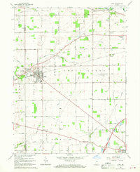
 1962 Ingalls1963 Print · USGSAs the mid-century suburban shift began to reach central Indiana, this area saw traditional farming intersect with growing communities and institutional landmarks. Genealogists can trace family names through sites like Hiday Cem, Beech Grove Ch, and the State Reformatory.3 unique versions available
 - 1967 Map of Lapel, 1968 Print
 1967 Lapel1968 Print · USGSWestern Madison County in the late sixties reveals a landscape of growing towns and established rail lines. Genealogists and local historians can trace the foundations of Lapel and Pendleton, or locate rural landmarks like Old Woodward Cemetery and the Old German Church.2 unique versions available
 - 1967 Map of Fishers, 1969 Print
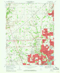
 1967 Fishers1969 Print · USGSNortheast of Indianapolis in the late sixties, this area shows the early pulse of suburban expansion along the White River. Genealogists and local historians can trace the foundations of Fishers, locate the Farley Cem, and see the early layout of New Britton and Allisonville.5 unique versions available
 - 1967 Map of Carmel, 1969 Print
 1967 Carmel1969 Print · USGSThe northern Indianapolis suburbs were rapidly expanding in the late sixties as new subdivisions began to replace farmland. Genealogists and historians can trace family locations near Eagle Village and Home Place, or locate early schools like Nora School and College Wood School.4 unique versions available
 - 1969 Map of Westfield, 1971 Print
 1969 Westfield1971 Print · USGSHamilton County farmland meets growing rural centers in the late sixties as the Monon railroad still defines the local transit corridor. Genealogists and historians can trace family locations near Union Grove Ch, Chester Cem, and the old settlement at Eagletown.2 unique versions available
 - 1969 Map of Riverwood, 1971 Print
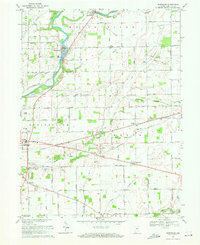 1969 Riverwood1971 Print · USGSHamilton County farmland meets the river in the late sixties as industrial sites and small communities dot the landscape. Researchers can trace family roots at Zimmer Cem and Hurlock Cem or locate old landmarks like the Consolidated Sch in Durbin.4 unique versions available
 - 1969 Map of Noblesville, 1971 Print
 1969 Noblesville1971 Print · USGSHamilton County experienced a mix of traditional agriculture and expanding suburban life during the late sixties. Genealogists can trace family names and sites through Riverside Cem, the Gray Friends Ch, and the historic Potter Bridge near the White River.3 unique versions available
End of results
Showing maps 1-14 of 14
Top cities of Hamilton County
- Carmel historical maps
- Fishers historical maps
- Noblesville historical maps
- Westfield historical maps
- Cicero historical maps
- Sheridan historical maps
See more
Frequently asked questions
- What are the different types of historical maps available for Hamilton County?
- What is the oldest map of Hamilton County?
- Where can I purchase historical maps of Hamilton County for my home or office?
- Where can I download high-res historical maps of Hamilton County?
- Are there historical topographic maps available for Hamilton County?
- Is there historical aerial imagery available for Hamilton County?
- Where are historical maps of Hamilton County sourced from?