1940s Maps of White Cloud, Indiana
Explore 2 historic maps of White Cloud from the 1940s. These maps offer a rare glimpse into what life looked like during the 1940s — showing old roads, neighborhoods, homes, and landmarks that have changed or disappeared over time.
Whether you're researching your family's past, planning a metal detecting trip, or studying how White Cloud's landscape evolved across the 1940s, these high-resolution maps are a powerful tool for exploring the history of this region.
- Focus on a specific era: All maps on this page are from the 1940s, giving you a focused view of this time period.
- See what’s changed: Compare century-old streets, trails, and buildings to today's modern landscape using overlays and satellite layers.
- Research with precision: Use these maps for genealogy, historical research, land use analysis, or educational projects.
- View, download, or print: Maps are fully viewable online in high resolution, and can be downloaded or printed for your own records.
Start exploring White Cloud's history through authentic maps from the 1940s. This is your window into the past.
White Cloud, IN maps
(2)- 1944 Map of Corydon West, 1955 Print
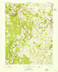 1944 Corydon West1955 Print · USGSHarrison County's rural landscape at the end of the Second World War is defined by the winding paths of Indian Creek and the Blue River. Researchers can trace old family footprints at Jordan Cem or locate former schoolhouses like Bickel Sch and Blair Sch.
 - 1947 Map of Corydon West
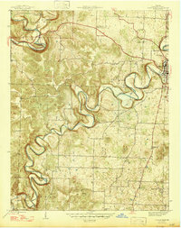 1947 Corydon West1947 Print · USGSHarrison County's river-cut landscape is shown here in the late 1940s, as the community centered around Corydon and the surrounding farmsteads. Genealogists and local historians can trace rural roots through landmarks like Jordan Cem, Heidelberg Ch, and Bickel Sch.2 unique versions available
End of results
Showing maps 1-2 of 2
Top cities near White Cloud
- Corydon historical maps
- Brandenburg historical maps
- Marengo historical maps
- Palmyra historical maps
- English historical maps
- Greenville historical maps
See more
Frequently asked questions
- What are the different types of historical maps available for White Cloud?
- What is the oldest map of White Cloud?
- Where can I purchase historical maps of White Cloud for my home or office?
- Where can I download high-res historical maps of White Cloud?
- Are there historical topographic maps available for White Cloud?
- Is there historical aerial imagery available for White Cloud?
- Where are historical maps of White Cloud sourced from?