1960s Maps of Hendricks County, Indiana
Explore 7 historic maps of Hendricks County from the 1960s. These maps offer a rare glimpse into what life looked like during the 1960s — showing old roads, neighborhoods, homes, and landmarks that have changed or disappeared over time.
Whether you're researching your family's past, planning a metal detecting trip, or studying how Hendricks County's landscape evolved across the 1960s, these high-resolution maps are a powerful tool for exploring the history of this region.
- Focus on a specific era: All maps on this page are from the 1960s, giving you a focused view of this time period.
- See what’s changed: Compare century-old streets, trails, and buildings to today's modern landscape using overlays and satellite layers.
- Research with precision: Use these maps for genealogy, historical research, land use analysis, or educational projects.
- View, download, or print: Maps are fully viewable online in high resolution, and can be downloaded or printed for your own records.
Start exploring Hendricks County's history through authentic maps from the 1960s. This is your window into the past.
Hendricks County, IN maps
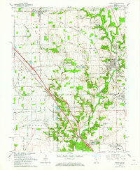
(7)- 1962 Map of Indianapolis
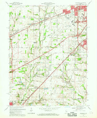
 1962 Indianapolis1962 Print · USGSCentral Indiana and the Illinois borderlands are captured here in the early sixties, showing the region's dense rail networks and growing urban centers. Genealogists and historians can locate family-named landmarks and institutions like Crown Hill Cem, Indiana University, and the Indianapolis Motor Speedway.
 - 1962 Map of Zionsville, 1964 Print
 1962 Zionsville1964 Print · USGSZionsville and the surrounding townships of Boone County are captured here in the early sixties as rural landscapes began to shift toward suburban life. Genealogists and local historians can trace family locations through numerous landmarks like McCord Cem, Salem Ch, and the settlement at Traders Point.
 - 1963 Map of Fayette, 1964 Print
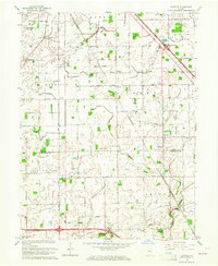 1963 Fayette1964 Print · USGSThe rural borderlands of Boone and Hendricks counties are captured here in the early sixties, showing a landscape of family farms and small crossroad hamlets. Researchers can trace the heritage of Milledgeville and Fayette or locate ancestral sites like Bethesda Cem and Cynthiana Ch.
 - 1965 Map of Mooresville West, 1966 Print
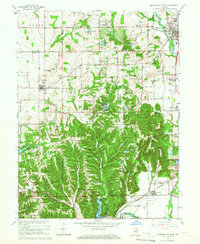 1965 Mooresville West1966 Print · USGSThe White River valley south of Mooresville is captured here in the mid-sixties, showing a landscape of state forests, rural parishes, and summer camps. Researchers can locate the Goethe Link Observatory, trace the Pennsylvania rail line, or find family roots at Bethesda Cem and Wilbur.3 unique versions available
 - 1966 Map of Zionsville, 1968 Print
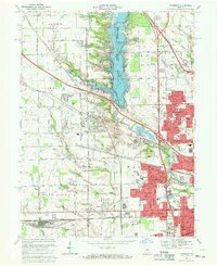
 1966 Zionsville1968 Print · USGSZionsville and Whitestown are documented here in the mid-sixties, just as the landscape began to shift with the creation of the Eagle Creek Reservoir. Local historians can trace family plots at Whitestown Cem and Jones Cem or locate old landmarks like the Macedonia Ch and Pitzer Hill.5 unique versions available
 - 1966 Map of Bridgeport, 1969 Print
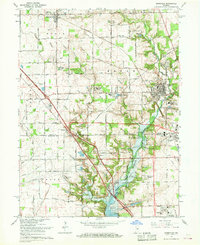
 1966 Bridgeport1969 Print · USGSMarion and Hendricks counties are captured here during a period of suburban transition in the mid-1960s. Researchers can trace the layout of Weir Cook Municipal Airport and find local history at Friends Cem and West Newton.4 unique versions available
 - 1967 Map of Clermont, 1969 Print
 1967 Clermont1969 Print · USGSThe western outskirts of Indianapolis are shown in the late sixties as suburban expansion meets established rural landmarks. Trace the development of the Eagle Creek Reservoir and find local history at Jodes Chapel Cem, the Indiana Girls School, and Snacks.3 unique versions available
End of results
Showing maps 1-7 of 7
Top cities of Hendricks County
- Plainfield historical maps
- Brownsburg historical maps
- Avon historical maps
- Danville historical maps
- Pittsboro historical maps
- Clayton historical maps
See more
Frequently asked questions
- What are the different types of historical maps available for Hendricks County?
- What is the oldest map of Hendricks County?
- Where can I purchase historical maps of Hendricks County for my home or office?
- Where can I download high-res historical maps of Hendricks County?
- Are there historical topographic maps available for Hendricks County?
- Is there historical aerial imagery available for Hendricks County?
- Where are historical maps of Hendricks County sourced from?