1970s Maps of Hendricks County, Indiana
Explore 8 historic maps of Hendricks County from the 1970s. These maps offer a rare glimpse into what life looked like during the 1970s — showing old roads, neighborhoods, homes, and landmarks that have changed or disappeared over time.
Whether you're researching your family's past, planning a metal detecting trip, or studying how Hendricks County's landscape evolved across the 1970s, these high-resolution maps are a powerful tool for exploring the history of this region.
- Focus on a specific era: All maps on this page are from the 1970s, giving you a focused view of this time period.
- See what’s changed: Compare century-old streets, trails, and buildings to today's modern landscape using overlays and satellite layers.
- Research with precision: Use these maps for genealogy, historical research, land use analysis, or educational projects.
- View, download, or print: Maps are fully viewable online in high resolution, and can be downloaded or printed for your own records.
Start exploring Hendricks County's history through authentic maps from the 1970s. This is your window into the past.
Hendricks County, IN maps
(8)- 1970 Map of Eminence, 1972 Print
 1970 Eminence1972 Print · USGSThe crossroads of Putnam and Morgan counties are captured here in the early seventies, showing a landscape of small farming towns and rural school districts. Genealogists can locate family sites at Walnut Chapel, the Whitaker-Patrick Cem, and the historic Covered Bridge.2 unique versions available
 - 1970 Map of Lizton, 1972 Print
 1970 Lizton1972 Print · USGSThe rural border of Boone and Hendricks counties comes to life in the early seventies, centered on the railroad town of Lizton. Genealogists and local historians can trace family ties at the Poplar Grove Cemetery or locate the Pinnell School and Old Union Church.
 - 1970 Map of Coatesville, 1972 Print
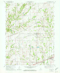 1970 Coatesville1972 Print · USGSIndiana farmland and rail corridors define the landscape between Coatesville and Stilesville during the early 1970s. Trace the paths of the National Road and the Penn Central tracks past local landmarks like Bethel Ch and Sunset Lake.3 unique versions available
 - 1970 Map of Clayton, 1972 Print
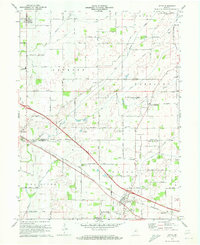
 1970 Clayton1972 Print · USGSSouthern Hendricks County at the start of the 1970s shows a landscape transitioning around its historic transit corridors. Genealogists can trace family names through sites like Old Spring Cem or locate the Drive-in Theater and Cascade Sch along the NATIONAL ROAD.
 - 1970 Map of Hall, 1972 Print
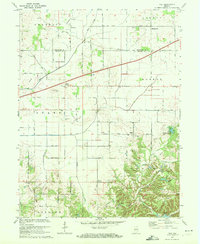 1970 Hall1972 Print · USGSMorgan and Hendricks counties are captured here in the early 1970s, showing a landscape of small crossroads settlements and family farms. Local historians can trace established rural landmarks like Mt Pleasant Cem, the community of Hall, and Mt Moriah Ch.2 unique versions available
 - 1970 Map of Plainfield, 1972 Print
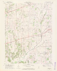
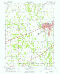 1970 Plainfield1972 Print · USGSPlainfield and the surrounding townships were rapidly evolving in the early seventies as the National Road and rail lines spurred new development. Genealogists and historians can trace family locations near Salem Ch, Spring Hill Cem, or the institutional grounds of the Indiana Boys School.3 unique versions available
 - 1970 Map of Danville, 1972 Print
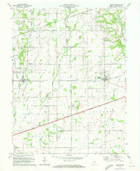
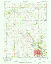 1970 Danville1972 Print · USGSThe Hendricks County seat at Danville and the surrounding township lands are captured here in the early 1970s. Genealogists and local historians can trace the paths of the Penn Central and Baltimore and Ohio railroads or locate rural landmarks like Mt Pleasant Cem and Montclair.
 - 1970 Map of Brownsburg, 1972 Print
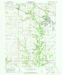 1970 Brownsburg1972 Print · USGSHendricks County is seen here at a pivotal moment of suburban growth during the early seventies. Genealogists and local historians can trace family roots through numerous burial sites like St Malachy West Cem and Abner Creek Cem or locate long-standing landmarks like Bartlett Chapel.3 unique versions available
End of results
Showing maps 1-8 of 8
Top cities of Hendricks County
- Plainfield historical maps
- Brownsburg historical maps
- Avon historical maps
- Danville historical maps
- Pittsboro historical maps
- Clayton historical maps
See more
Frequently asked questions
- What are the different types of historical maps available for Hendricks County?
- What is the oldest map of Hendricks County?
- Where can I purchase historical maps of Hendricks County for my home or office?
- Where can I download high-res historical maps of Hendricks County?
- Are there historical topographic maps available for Hendricks County?
- Is there historical aerial imagery available for Hendricks County?
- Where are historical maps of Hendricks County sourced from?