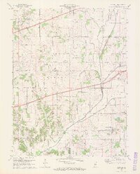
1970 Map of Eminence
USGS Topo · Published 1972About this map
The Eminence community and its surrounding agricultural landscape are documented here at the start of the 1970s, where Putnam, Morgan, and Hendricks counties meet. This rural area is defined by a dense network of small waterways, including Mill Creek, Cotton Branch, and Sallust Branch, which historically shaped the placement of early settlements. The map highlights the localized infrastructure of the era, such as the Consolidated Sch in Eminence and the Township Sch near Belle Union. Significant for local history is the presence of several religious and memorial sites, including Walnut Chapel, Union Valley Ch, and the Whitaker-Patrick Cem. A notable engineering landmark, the Covered Bridge, spans the waters where the county lines converge, while the historic National Road cuts across the northern landscape, reflecting the region's long-standing role as a corridor for Midwestern travel and commerce.
Find a feature on this map
34 named features on this map. Tap any name to fly to it.
Don’t see what you’re looking for? This feature index may not catch every label — zoom into the map to look around manually.
Map Details
Editions of this 1970 Eminence Map
2 editions found
Other maps of this area

1949 · Quincy
USGS Topo · 1:24,000

1953 · Clayton
USGS Topo · 1:24,000

1953 · Indianapolis
USGS Topo · 1:250,000

1955 · Hall
USGS Topo · 1:24,000

1956 · Indianapolis
USGS Topo · 1:250,000

1956 · Cloverdale
USGS Topo · 1:24,000

1956 · Cataract
USGS Topo · 1:24,000

1956 · Eminence
USGS Topo · 1:24,000

1957 · Indianapolis
USGS Topo · 1:250,000
1957 · Paragon
USGS Topo · 1:24,000