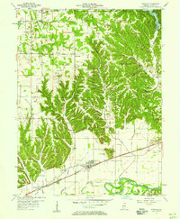
1957 Map of Paragon
USGS Topo · Published 1958About this map
Paragon sits at the heart of this Morgan County landscape, where the flatlands of the White River valley meet the dissected uplands of southern Indiana. The Pennsylvania railroad and the Memorial Highway provide the primary east-west corridor through the river valley, connecting the town with Whitaker and the whistle-stop at Browns Crossing. The northern half of the sheet is dominated by rugged topography, featuring family-named summits like Shumaker Hill and Big Hurricane Hill. This area is dotted with small, localized settlements such as Rattsville, Wakeland, and Plano. Genealogy researchers will find numerous rural burial grounds and congregations preserved here, including Ratts Cem, Bethlehem Cem, and Olive Ch, many of which are tucked away along the winding courses of Snake Creek and Lambs Creek. A Pipeline cuts a distinct linear path across the central hills, contrasting with the sinuous Harrison Ditch that drains the lowlands.
Find a feature on this map
45 named features on this map. Tap any name to fly to it.
Don’t see what you’re looking for? This feature index may not catch every label — zoom into the map to look around manually.
Map Details
Editions of this 1957 Paragon Map
This is the sole edition of this map. No revisions or reprints were ever made.
Other maps of this area

1942 · Franklin
USGS Topo · 1:125,000

1947 · Gosport
USGS Topo · 1:24,000

1948 · Hindustan
USGS Topo · 1:24,000

1949 · Quincy
USGS Topo · 1:24,000

1950 · Gosport
USGS Topo · 1:24,000

1953 · Indianapolis
USGS Topo · 1:250,000

1955 · Hall
USGS Topo · 1:24,000

1955 · Mooresville West
USGS Topo · 1:24,000

1955 · Martinsville
USGS Topo · 1:24,000

1956 · Indianapolis
USGS Topo · 1:250,000