
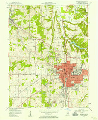
1947 Map of Gosport
USGS Topo · Published 1958About this map
The White River meanders across the northern half of this landscape, anchoring the commercial hubs of Gosport and Romona. In the late 1940s, this region of central Indiana was defined by its transition from the river valley to the limestone-rich uplands of the south, where the settlement of Stinesville sits near Defeat Creek. The map provides exceptional detail for genealogists, documenting numerous rural landmarks such as Shiloh Ch, Old Dutch Ch, and Laymon Ch, along with the Chambersville Cem near Highets Corner.
Find a feature on this map
40 named features on this map. Tap any name to fly to it.
Don’t see what you’re looking for? This feature index may not catch every label — zoom into the map to look around manually.
Map Details
Editions of this 1947 Gosport Map
This is the sole edition of this map. No revisions or reprints were ever made.
Other maps of this area

1908 · Bloomington
USGS Topo · 1:48,000

1908 · Bloomfield
USGS Topo · 1:62,500

1910 · Bloomington
USGS Topo · 1:62,500

1949 · Quincy
USGS Topo · 1:24,000

1950 · Gosport
USGS Topo · 1:24,000

1953 · Indianapolis
USGS Topo · 1:250,000

1956 · Indianapolis
USGS Topo · 1:250,000

1956 · Cataract
USGS Topo · 1:24,000

1956 · Freedom
USGS Topo · 1:24,000
1956 · Bloomington
USGS Topo · 1:24,000