
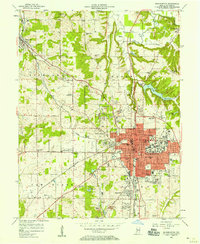
1950 Map of Gosport
USGS Topo · Published 1950About this map
The West Fork White River carves a winding path through the heart of this Indiana landscape, defining the boundaries and topography near the mid-century. The town of Gosport sits on the northern bank, a rail hub where the Pennsylvania line meets the Chicago Indianapolis And Louisville tracks. To the south, Mc CORMICKS CREEK STATE PARK occupies a significant portion of the terrain, featuring the landmark Lookout Tower and the natural wonders of Wolf Cave and McCormicks Creek. This area is characterized by its transition from industrial river valley to protected woodland.
Find a feature on this map
42 named features on this map. Tap any name to fly to it.
Don’t see what you’re looking for? This feature index may not catch every label — zoom into the map to look around manually.
Map Details
Editions of this 1950 Gosport Map
This is the sole edition of this map. No revisions or reprints were ever made.
Other maps of this area

1908 · Bloomington
USGS Topo · 1:48,000

1908 · Bloomfield
USGS Topo · 1:62,500

1910 · Bloomington
USGS Topo · 1:62,500

1947 · Gosport
USGS Topo · 1:24,000

1949 · Quincy
USGS Topo · 1:24,000

1953 · Indianapolis
USGS Topo · 1:250,000

1956 · Indianapolis
USGS Topo · 1:250,000

1956 · Cataract
USGS Topo · 1:24,000

1956 · Freedom
USGS Topo · 1:24,000
1956 · Bloomington
USGS Topo · 1:24,000